It was late 2018 when I got off from a FlyDubai's Boeing 737 airplane. A cold breeze of the evening Himalayan air struck my face as I walked along the familiar, old rustic hallway towards the arrival hall.
The dusty red brick walls of this airport reminded me of the first time I arrived here back in 2013. The confusion and excitement that swept over me the moment I arrived did the same again 5 years later.
The moment my senses engaged with the sound, the sights, and the aroma of the city as I walked out from the airport, I knew right away that a grand adventure awaited, just like it did in 2013. I was finally back in a country where it all began, where the trajectory of my life spun upward and shaped the person I am today. I'm finally back in Nepal again.
It was the month of my birthday when I arrived at Tribhuvan International Airport in Kathmandu, and I had my goal set on an adventure I had always wanted to do on my birthday.
Ever since I started traveling back in 2013, I have always made the effort to do something distinctly untraditional. I spent my 2014's birthday skydiving in New Zealand, 2015's birthday dancing to a German rap battle in Dresden, 2017's birthday trekking the Santa Cruz Trail in the Andes alone, and 2018 was no different.
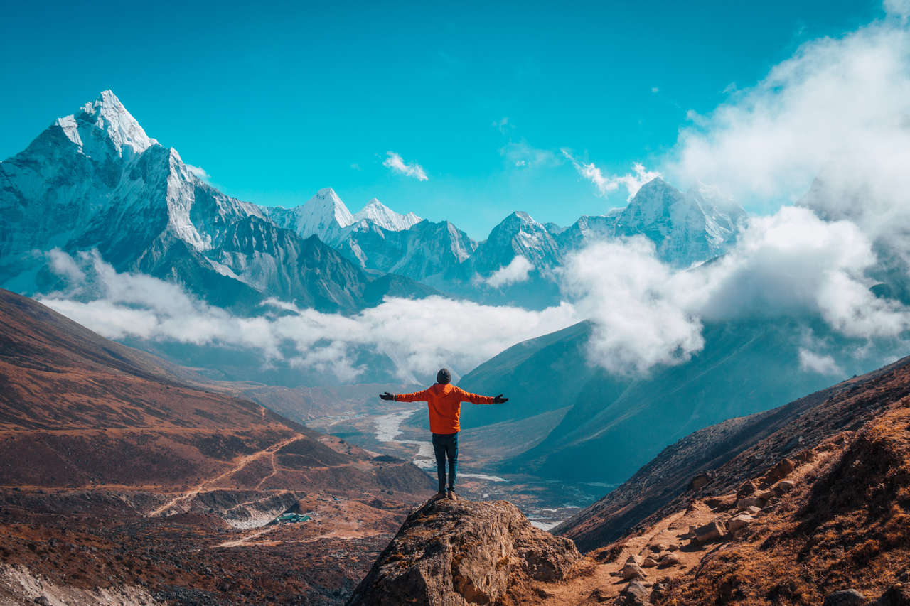
For 2018, I had my sights set on Everest Base Camp, a supply camp on the south face of Mount Everest standing at 5,364 meters above sea level, and the route there is no walk in the park.

Watch Never Everest Travel Video
Watch on Youtube
The Route to Everest Base Camp
The route to Everest Base Camp is a journey that requires not only commitment and dedication but also a razor focus of willpower and determination that one would need to get themselves through 4-8 hours of hiking each day.
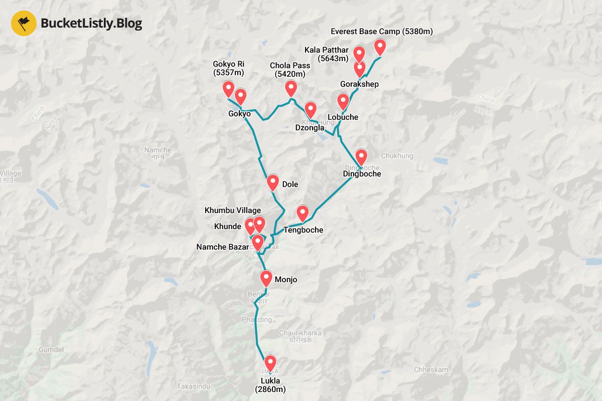
To get to Everest Base Camp, one would need to fly into Lukla Airport, one of the most dangerous airports in the world (you will see why soon), trek along Dudh Kosi River to the Sherpa capital of Namche Bazaar at 3,867m, before heading up to Dingboche (4,260 meters), Lobuche (4,930 meters), Gorakshep (5,140 meters), and eventually to Everest Base Camp (5,364 meters), all in a span of 7 days.
Instead of coming down the same way, I decided to go even further and add a side-trek to Gokyo Lakes (5,000 meters), which takes 3 extra days before heading back to Namche Bazar, Lukla, and eventually Kathmandu. In total, it would take me around 15 days, just in time for my birthday.
It was the ultimate challenge I set up for myself on my 30th birthday, a big day for anyone who knows the feeling of entering the infamous 30s age-range. And there is no better way to convince yourself that you are still young at heart than to do something crazy like trekking to Everest Base Camp solo 😁.
Flying into Lukla: One of the Most Dangerous Airports in the World
And so, my journey to solo-trek the Everest Base Camp trail began. The first thing I had to do to prepare for the terrifying flight from Kathmandu to Lukla airport was to shed some weight off my backpack.
As I have mentioned earlier, Lukla is one of the most terrifying airports in the world. Due to its remote location atop a mountain at 2,860 meters above sea level, surrounded by the foothills of the Himalayas and with its limited area, the airport's runway had to be built on top of a small cliff.
The runway of Lukla Airport is 527 meters long and 30 meters wide, with an 11.7% gradient, making it one of the shortest runways out there. This means that if the aircraft comes in too fast, it will hit the mountain, and if it is too slow, it will hit the cliff before landing. That is why it is only accessible via helicopters and small aircraft.
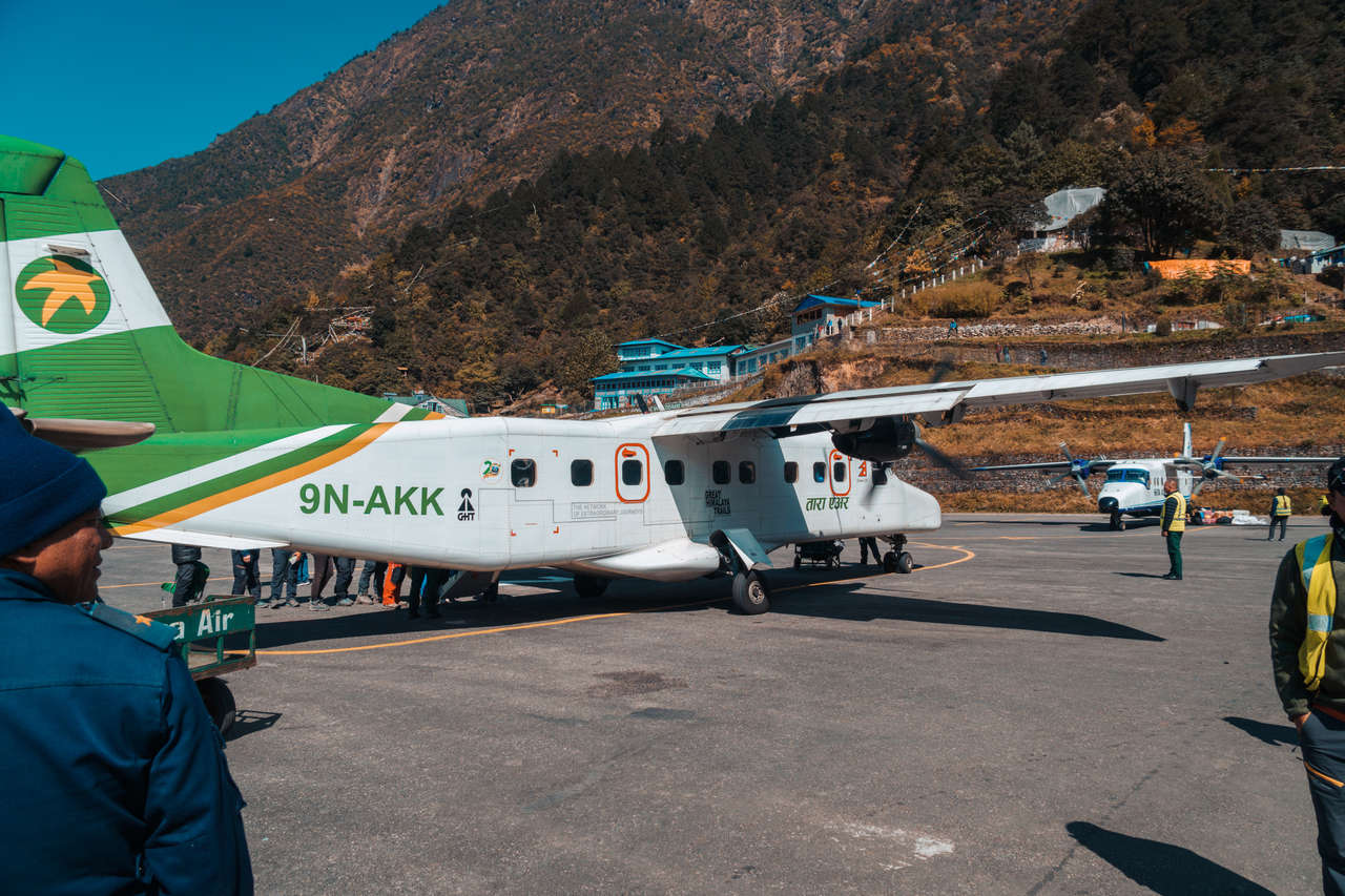
The DHC-6 Twin Otter 300 aircraft operated by Yeti Airlines, which can carry up to 22 people, has a luggage allowance of 10kg per person. In order to meet that limit, we backpackers had to be quite creative compared to usual.
Since they only weigh your backpack at check-in, you can reduce weight by wearing some of the clothes you are taking and carrying the rest on board. That is exactly what I did, walking into the waiting area with my daypack and a ton of camera gear in a plastic bag, like a scavenger.
My flight was scheduled at 9:30 AM, but if you have dealt with the weather in the mountains before, you know that time means nothing at all. It was mostly just an estimate of the time an airplane can take off safely.
Due to several uncontrollable variables, there is a high chance that the flight might be canceled. I knew deep down that I could get stranded at some point, since the flight from Kathmandu to Lukla is notorious for that, often leaving people stranded for days and sometimes weeks.
As the hour hand ticked from 10 to 11 to 12, my heart started to sink. "My journey hasn't even begun yet, and I am already stranded", I thought to myself. Then, I shook off the negative feeling as I realized I have been prepared for this.
A friend once told me, "Nothing works the way it should be in Nepal. Prepare for the worst and leave wiggle rooms for when that happens." He told me a story of what it was like to be stranded in Kathmandu due to protestors shutting down airports, preventing him from leaving the country.
With that horror story embedded deep in my mind, every time I plan a trip to Nepal, I always arrange a few buffer days in case something goes wrong. This trip was no different.
I decided not to book my flight out of Nepal and instead leave it until I get back from the mountain, so that I do not have to stress out in such a situation.
By 2 PM, I finally heard the announcement I had been waiting for for 5 hours: my Yeti flight 153 was finally commencing and ready to take me to Lukla. I heaved a sigh of relief as I lined up to get on a small double-turbine aircraft among 20 other excited backpackers, fully geared up to a tee, ready to trek the Himalayas.
There are 3 tiny seats on each row, and there are around 20 people packed inside the small aircraft. The ceiling of the aircraft is so low that not even the flight attendant can stand up straight as she goes around checking and giving us candies for take-off.
Within minutes, as the howling engine shook the entire aircraft and the deafening turbines spun vigorously, we were off the ground. Like any small turbine aircraft, it was impossible to hear anything, not even your own nervous breathing of anticipation and fear.
As the aircraft pierced the sky, the scenery shifted from the rustic bustling cityscape of Kathmandu to the rolling hills of the Nepalese mountains. Within 30 minutes, snow peaks started to appear outside the aircraft's window. "Finally", I thought to myself, "this will be the best birthday gift I have ever given myself."
As my excitement soared, the announcement came through the telecom of the open-door cockpit: we were about to land. As the aircraft pointed its head down towards the mountain, I got a glimpse of the infamous runway of Lukla airport.
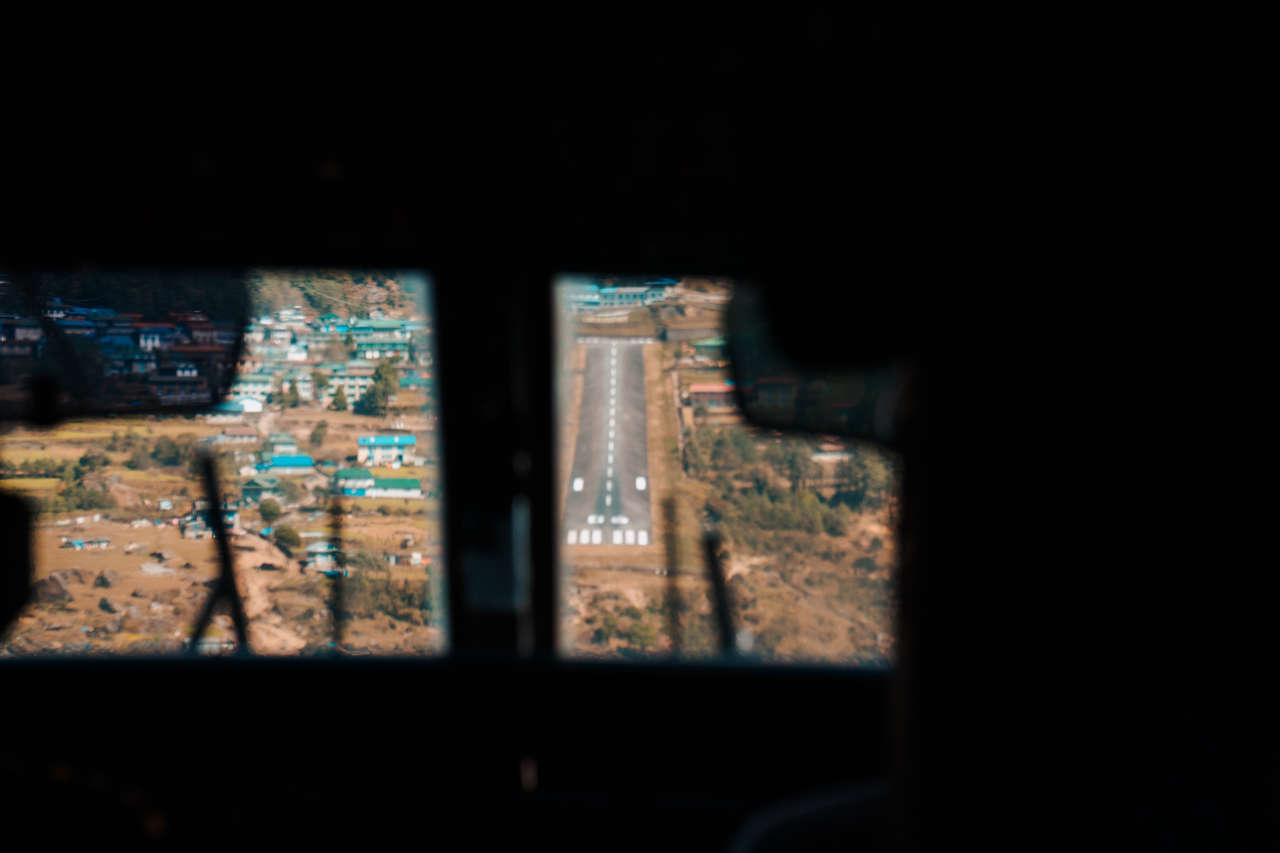
I knew the runway was short, but I didn't realize how short it actually was until I saw it with my own eyes. The runway was so short that I was able to see the entire length of it through the small cockpit windows.
My excitement turned into fear as I let out a little gasp, and my hands thrust out and clutched the armrest. "If it comes in too hot, we hit the mountain; if not, we hit the cliff." Every scenario my mind could conjure, it did in a split second. My mind often loves when it wanders, but this was not the time.
As the aircraft decelerated and descended from the clouds to the runway, there was a moment of silence, a split second of quietness and solitude, right before it hit the ground. I was then brought back to reality as the aircraft's wheels glided along the runway, fighting against its own acceleration.
The aircraft shook violently as the spoilers on the wings activated, reducing the aerodynamic lift and increasing the drag. This happened while the aircraft continued to decelerate before ultimately coming to a stop.
The whole landing procedure probably took a few minutes, but in my mind, it felt like it took forever. As the aircraft came to a stop, I, among other backpackers, let out a giant sigh of relief. I did not realize I was sweating so much until I let go of my armrests and saw how sweaty my palms were.
Everything was Now on Me
As I got out of the aircraft, the wind struck my face again, but this time, it was different. The air felt fresher, the aroma of the city was replaced by the rich vegetation of the Himalayas, and the sight of the colorful prayer flags flapping against the wind was a welcome change from the dusty streets of Kathmandu.
And there, at that moment, as I settled into my room at a teahouse called Everest Lodge in Lukla, reality struck again. It was the realization that from this point on, everything was on me. I would be responsible for my own life, accidents, and mistakes from this point onward.
To be honest, realizing that you and you alone are responsible for your life from now on is both scary and rewarding at the same time. On the one hand, you can no longer blame anyone for your mistakes, which is something we humans often do, intentionally or unintentionally, to make ourselves feel better.
On the other hand, relying on yourself and being able to accomplish what your mind is set out to do is one of the most rewarding feelings you can have in life. It is that intoxicating feeling of a natural high on all the possibilities, accomplishments, and the sense of growth and progress that set me out on this journey to the top of the world.
The Disappearing Camaraderie on Hiking Trails
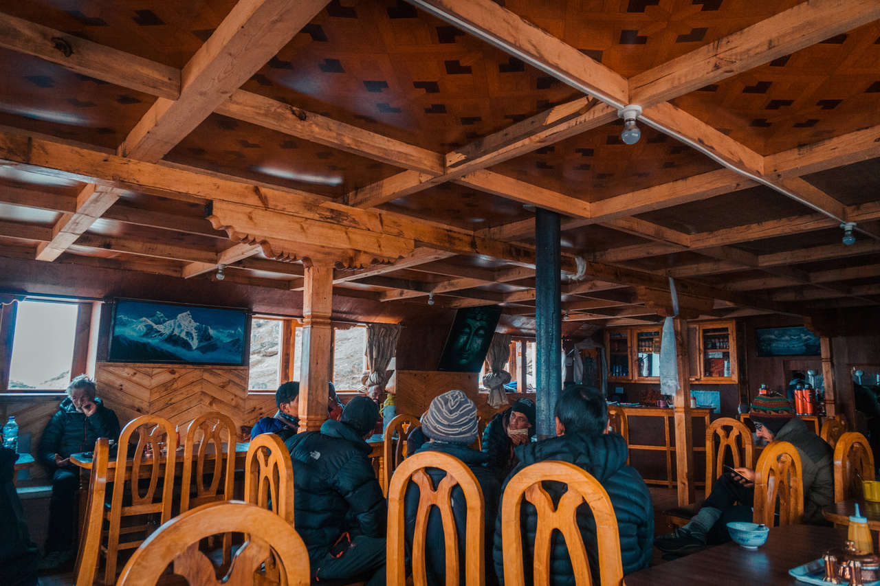
As I was sitting at a dining table in the common area of Everest Lodge, hanging out with the owner of the place and plotting my itinerary to tackle the Everest Base Camp, a group of Italian hikers entered the room, sat at the large table, and started ordering dinner.
One of the things that got me hooked on trekking mountains is the camaraderie you get from the people you meet along the way. It is the sense of sharing a goal, like we are all in this together, that helps people to connect with each other on a much deeper level than those you meet elsewhere.
I remember the first time I trekked in Nepal. It was a 7-day trek to the Annapurna Base Camp, and as I dragged my body up the mountains, I met so many great people who kept me going until the end.
A couple of Israeli hikers and I hiked together for most parts of the trail, encouraging each other, arranging to be at the same teahouse, and they even went as far as to offer to share a room with me as the teahouses were running out of rooms that day.
Five years later, and I still remember them to this day. This is why I enjoyed hiking so much. People living in society these days often focus too much on themselves, forgetting to look around and see potential friendships within other strangers.
As the Italians walked in, I was certain that they would strike up a conversation with me and a few others sitting around the dinner table, just like my previous experience. However, as they came in, they chose to isolate themselves, sitting at their own pre-arranged table, and spent the night ordering pizzas and socializing among themselves.
Apparently, they were in a large tour group, and everything was pre-organized, so there was no need for them to socialize with anyone except themselves. Unfortunately, this was going to be a recurring theme I would see repeatedly in many of the teahouses I would be staying at throughout this journey.
The beauty and camaraderie that made me fall in love with trekking in Nepal are now disappearing and being replaced by these large tour groups that occupy most of the dining tables in teahouses, leaving very little room for us independent hikers to exist.
That night, I retreated to my chamber early as I completed my plan for the next day. My plan was to wake up as early as I could and trek a 2-day worth of trail (17.7km) all in one day from Lukla to Namche Bazar.
Early Birds Get the Worms
Most people often start their trek the same day they arrive in Lukla and stay overnight in Modjo before heading to the Sherpa's capital of Namche Bazar. However, my flight was late and we arrived a little too late to start the hike. Therefore, I decided to stay in Lukla that night.
6 AM and the alarms on my phone started buzzing. As I opened my eyes, confused as to where I was at first, the peaceful sound of birds chirping and prayer flags flapping in the morning breeze of the Himalayas brought me back to the real world. "Today is the day I start my journey", I thought to myself as I jumped out of bed and prepared my gear.
I left a bunch of unimportant things with the owner of the guesthouse, had delicious fried eggs and masala coffee for breakfast, and by 7 AM, I hauled up my 10kg backpack and was on my way to Namche Bazar.
Even though the sky was clear, it was still quite early, and most of the trails would be in the mountain shade before midday. I started off walking through the quiet streets of Lukla. It was early, but many hikers were already preparing for the day.
Waking up early, as I have found, is a common trait among mountain people like us. When the weather is this good in the morning, it would be unwise not to take advantage of it and start the day early. You never know when the weather would turn in the mountains, and that is why I am a morning person. We get the good weather and the whole trail to ourselves.
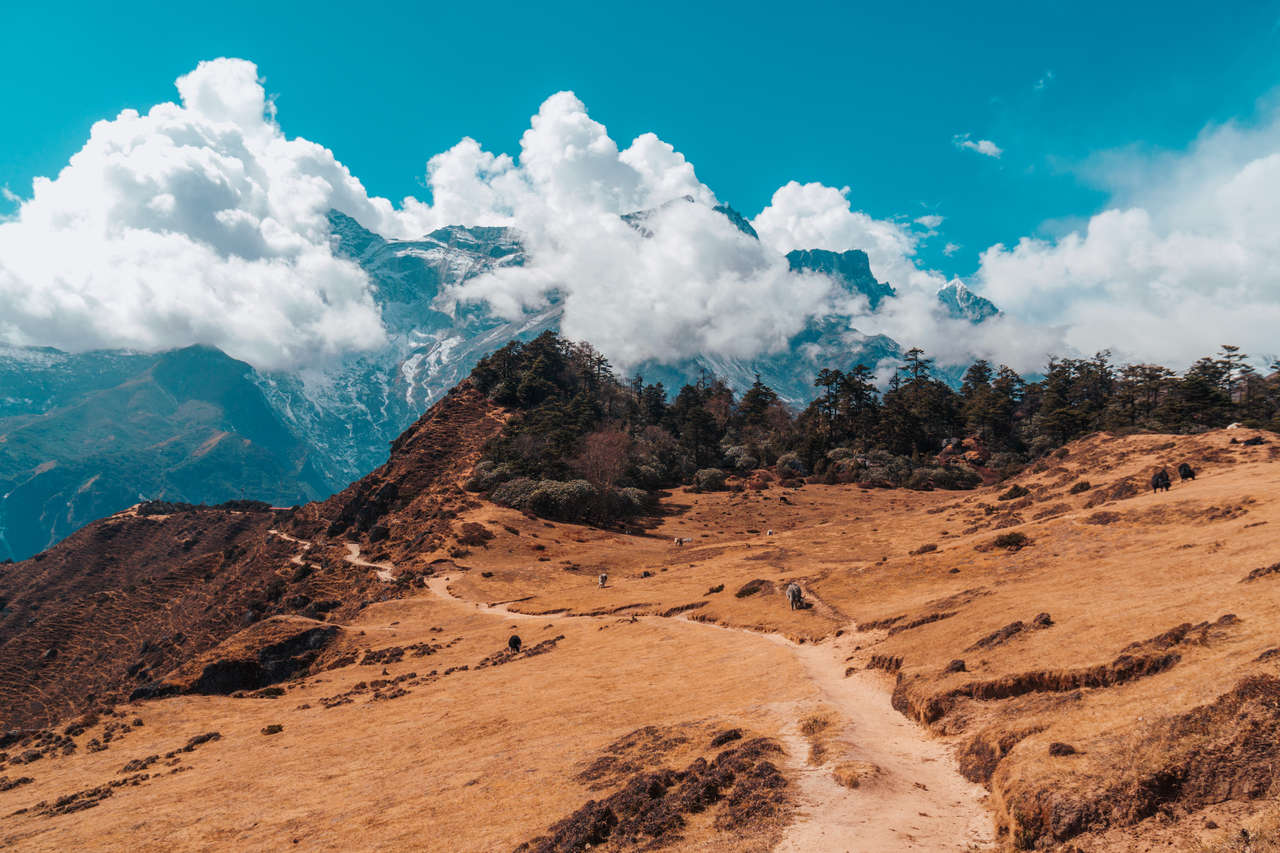
The trail started out with a descent into the valley as I sped through it, trying to create enough body heat to keep myself warm while hiking in the shade. It was a long, easy first half of the day. The first 3 hours of the trail were somewhat easy, but with a destination that is 1,000m away vertically, I knew in my mind that the more I went down, the more I would have to hike up to gain altitude. My mind was ready, but my body definitely didn't get the memo.
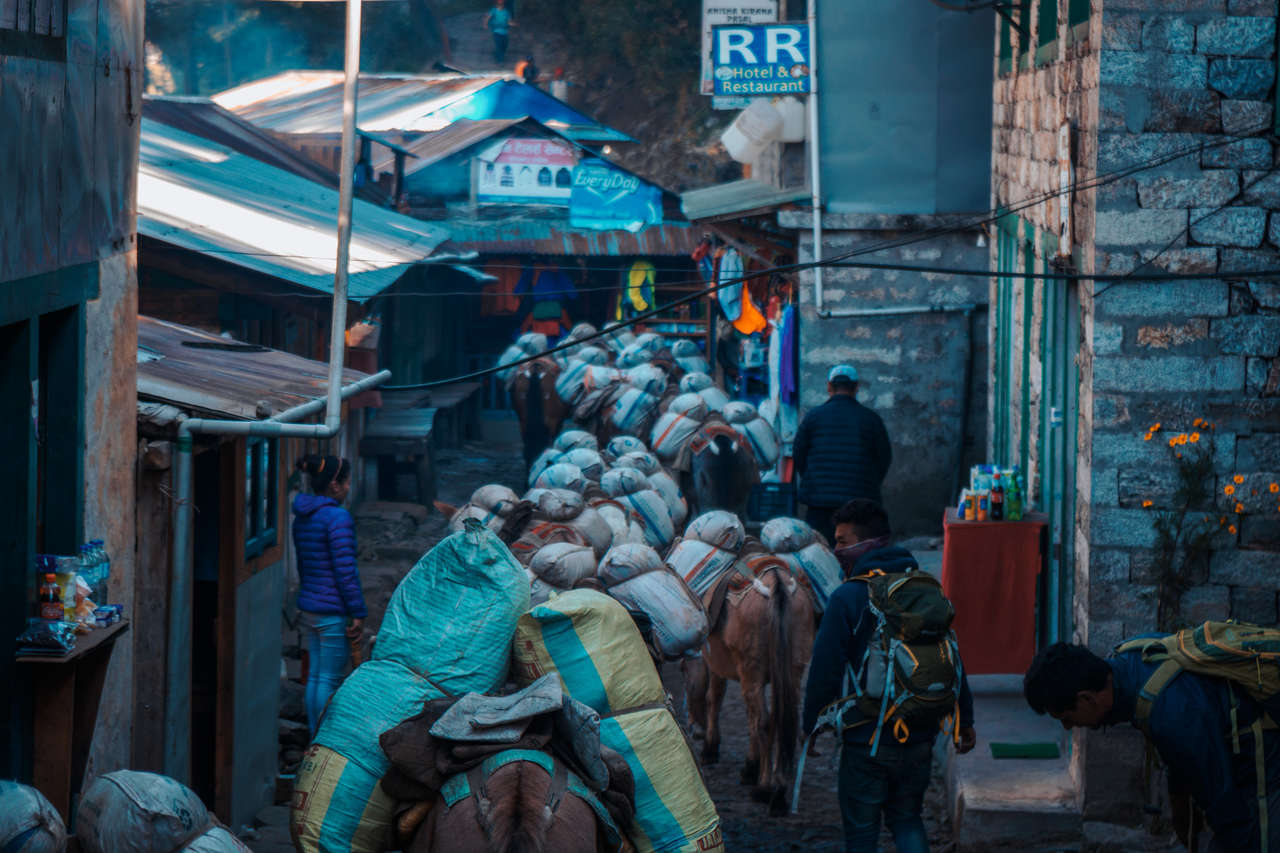
As I passed through Phakding at a record speed, the sun started to come out a little from the mountain. From the empty trail that I experienced in the early morning, it had now turned into a nature highway, with porters and their livestock flocking along the trail, trying to make their way to Namche Bazaar.
Sharing the Trail with Animals
Trails along the Everest Base Camp are often quite large, as the trail has become more and more commercialized over the years. In 2019, there were over 40,000 tourists traversing this trail alone in Nepal. As more and more people travel the route, businesses in the Sherpa's capital of Namche Bazar also grow. In order to sustain the booming tourism industry at 3,800 meters above sea level, supplies and logistics are the lifeblood of the economy up there.
These porters and their mules handle the logistical part of this economy. Many times on my way to Namche Bazar, the trail often comes to a complete halt as the porters slowly lead their livestock along one of the many suspension bridges across the valley one by one.
As an observer and outsider, it was fascinating to see the organization and management required to put this livestock in line. However, as a hiker, it can be quite dangerous sharing the trail with several mules strapped with 2 large gas tanks on their sides.
As with most animals tamed in this way, when they walk, they are often unaware of the objects they are carrying. Therefore, when they pass you, it is your responsibility to dodge whatever comes your way.
I learned this the hard way a few times when I was in Nepal 5 years ago because there were several occasions when I got bumped by gas-tank-equipped mules as they were climbing up the trail with me. Thankfully, I was on the mountainside of the trail when that happened. Imagine what would happen if I were on the cliffside of the trail. That is why whenever I am sharing a trail with an animal, I will always stick to the mountainside no matter what.
As I left Phakding, seeing Modjo on the horizon, I rushed on, trying to make it in time for lunch. But as I was hiking on a flat, sandy trail along the cabbage field, I felt a sudden thrust behind my back, so fast I almost flew up into the air. It was one of the leading gas-tank mules that ran forward from the pack, hitting right on my backpack and throwing me off the trail. Fortunately, I was able to land on my two feet after it happened.
I was bewildered and a little shaken up as I regained my senses and stared at the porter in charge of that flock. He stared right back at me, unsympathetic, almost as if he was blaming me for being in the way, and not a single apology was uttered from his mouth. He continued on as if nothing had happened and disappeared into one of the villages before Modjo.
As I was having lunch in Modjo, the thought of that little accident came back to me. I was pretty lucky, considering that I was hit by a running mule on a pretty wide trail, nowhere near a cliff. It was a hard hit, but my backpack absorbed most of the force, allowing me to recover mid-air and land without a scratch.
Here is the thing about nature: you can never really plan 100% for anything when you are hiking or trekking in the mountains. Whenever you share a trail with animals like this, things might go south even if you have taken all the precautions there are. Things just happen for no reason.
That was the case for me. There was no way I would be able to avoid that incident. Heck, I didn't even know it was coming until I was already off the ground. But at least it didn't end up as a total disaster, and for that, I am grateful.
The Ascension to the Sherpa's Capital
By 1 PM, I was already out of Modjo and on my way to Namche Bazar. From Modjo, it is another 1 hour of easy strolling and then 2 hours of an extremely steep climb before I would be in the vicinity of the final area of comfort, Namche Bazar - the last big town before complete isolation from civilization.
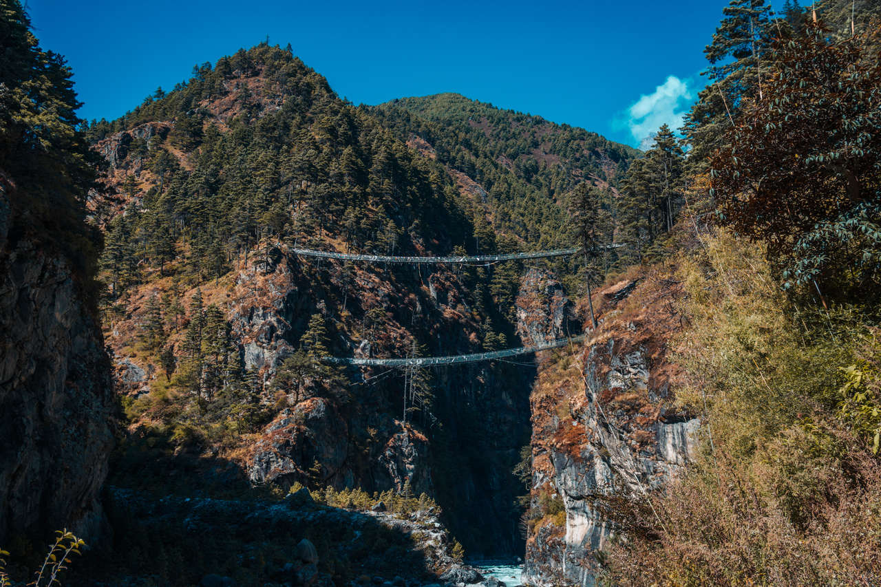
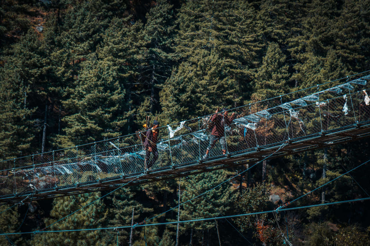
As I had already been hiking for 6 hours that day, the last 2 hours of a steep climb that came after I arrived at one of the landmarks of the trail, the double suspension bridges named Hillary Bridge after Edmund Hillary, were no easy task.
I was starting to feel my 10kg backpack weighing me down a bit as I strode on, one step at a time. There were a lot of people along the trail now at this point, as everyone was scrambling their way up the dusty trail to Namche Bazaar.
The trail zig-zagged through the forested hills, as I saw more and more people resting, catching their breaths along the way. I continued on as I often do, always moving, never resting for long to keep my engine going, and focusing on my footing, not my destination.
After hiking for several years now, I have come to realize that everyone has their own hiking pace. Some people might go fast and rest often, while others might go slow but never rest. I have come to learn that I am in the latter camp as I found it easier for me to manage my breathing that way, which is extremely important when it comes to hiking in high altitudes like this trail.
That is why I like hiking alone. I do not feel the pressure to follow or slow down for others when I hike. I just do what I do best, pacing myself out until I reach my destination, eventually.
The People of the Mountain
After 3 hours of scrambling my way up the trail, I had finally reached the end of the trail, or so I thought. Right before I entered Namche Bazar, I saw a long queue and several backpackers sitting and waiting in a hut that looked like a checkpoint. This was where every hiker has to register before one can proceed.
As the line was quite long when I arrived, I decided to take a little rest, dropped my backpack to the ground, and immediately felt like I was 100 kg lighter. It was a good feeling, not having to carry my backpack for the time being.
As a bunch of us were lining up to be registered, we all started sharing our itineraries with each other. As I had come to learn, many people were doing the Everest Base Camp. Some were doing Everest Base Camp and Gokyo Lakes, as I did. A few were tackling the Three Passes Trek, which is a longer and tougher trail that takes you to both Everest Base Camp and Gokyo Lakes, but through 3 of the high passes.
That was the first time I had heard about the Three Passes route. I would be lying if I said I had come prepared for this trip, but if you know me, planning is not something I often do.
As I talked more and more with these hikers, I had come to enjoy their brief company. There was a hippie couple from Australia who I found were 2 of the best listeners I met on this trip. They were extremely chill and listened to everyone's stories with open hearts.
There was also a Singaporean guy who had recently completed the Annapurna Circuit, another 15-day trek in the Annapurna region, a few days prior to coming to tackle Everest Base Camp. If only I had the same energy as he had 😅.
The feeling of camaraderie I felt many years ago swept through me like a warm summer breeze. This felt right. This was the mountain culture, where everyone is everyone's friend by default, where everyone said hi to everyone. It felt like the place I fell in love with 5 years ago again.
After 30 minutes of waiting in line, we went our separate ways as we continued up for about 10 minutes before arriving at the Sherpa's capital of Namche Bazaar.
The Sherpa's Capital of Namche Bazar
Namche Bazaar is the main trading city for over 1,500 people on a sloping hill at 3,440 above sea level within the Khumbu region. You can find mountaineering shops selling knock-off North Face jackets, a French bakery, and an Italian cafe. There is even a hair salon. They also have a working ATM, which saved my life as you will soon see in a few days.
One of the most dangerous things about hiking in high altitude is the risk of getting AMS or acute mountain sickness, a negative health effect of high altitude caused by the rapid exposure to the low amount of oxygen from being in a high altitude environment such as what I was experiencing.
AMS does not pick its victims. Even the fittest of us all might get it one day if they are not careful. The key to keeping this under control is to slowly expose yourself to low oxygen gradually over time so that your body can acclimatize.
Since I had just come from Kathmandu the day before, which stands at 1,400 meters above sea level, slept at 2,860 meters in Lukla, and hiked the entire day to 3,440 meters to Namche Bazar, I was gaining altitude a little too fast. It was wise for me to stop in Namche Bazar for 2 nights to acclimatize before heading further up.
As I settled into the Khumbu Lodge teahouse, I got to talk with the owner of the lodge. He is a big fan of Thailand and always visits the country during winter months when the town is closed. He was a quiet but friendly man who runs his lodge and treats his customers like family.
We talked about the highs and lows of the tourism industry up at 3,000 meters above sea level, the shifts and changes the city was undergoing due to the explosive growth of tourism in recent years. He enjoyed going on holidays in Thailand, away from the freezing winter of the Himalayas. He was fun to talk to and able to give me great insights into the people living in Namche Bazar.
At dinner time, as I expected, many of the large tables were occupied by tour groups, and only a few tables were left for those of us solo hikers. I was seated with a German girl that night, and as her blonde hair brushed up against her red sunburned cheek, I started talking to her.
As I had come to learn through her stories, she did not take the plane up to Lukla as I did. She hiked from Jiri, a town halfway between Kathmandu and Lukla, all the way to Lukla on foot. It took her 2 weeks!
As if that wasn't awesome enough, she continued on and shared that she would be doing the Three Passes trail, the hardest route one can take to Everest Base Camp. "Damn, this woman is awesome", I thought to myself. If only I had the guts to do the Three Passes as she was.
As each of us was about to retreat to our own rooms, we decided not to say goodbye that night but instead, we said "see you later", as if we would cross paths again somehow in the near future. You never know when it comes to travel friends like her. We might meet each other again in 3 months' time in some other cool places; who knows.
Right before she went to bed, she asked me if what I was wearing was all I had. The night in the Himalayas is cold, even colder than during the day when you are sweating from hiking. As I was sitting there with my t-shirt under a fleece jacket under a bright orange lightweight Columbia outer shell, I nodded reluctantly.
"You'd better get another jacket before you leave Namche Bazar because it's just going to get colder from here on out", she commented, and I nodded silently as she turned back and walked out of the dining room.
To be honest, I was a little skeptical of her suggestion at first, as my ego told me that I knew what I was doing. However, as my ego deflated, my reasoning reminded me of the one fact I had learned after years of hiking in the mountains: no two mountains are the same.
I may have hiked the Andes, the Upper Caucasus, and the Himalayas before, but all those trips went well only at the mercy of Mother Nature. Things could go wrong at any moment in the mountains, and it would be unwise not to heed the warning and prepare for the worst.
The next morning, I went out and bought myself a down jacket and a pair of warm, padded long pants, which would come in handy very soon as I gained elevation, as she had foretold.
The Culture of the Sherpas
On my acclimatization day in Namche Bazaar, I decided to spend the day hiking around the region, checking out the mountain villages of Khunde, home to a hospital founded by Sir Edmund Hillary, and Khumjung, where he also commissioned a school.
This was a great chance for me to learn more about the culture of the people in this region. Both villages are located on the slopes of the Khumjung Valley, at about 3,800 meters - 4,000 meters above sea level, making it a perfect day trip to acclimatize my body with the ever-increasing altitude.
I set off as early as 8 AM that day, just as the roosters crowed and the sun emerged from behind the mountains. I headed north, effortlessly climbing out of Namche Bazar. It was the first time I didn't have to carry my full backpack while hiking, which was a welcome change. I had a love-hate relationship with my backpack throughout my journey, so this was definitely a pleasant surprise.
The ground was damp, and the grass glistened in the early morning dew as I set foot on the trail towards Khunde. It took only 2 hours before I arrived at the gate of Khunde village and was greeted by the Eyes of Wisdom, a symbol of wisdom and compassion that is often seen on a stupa in Nepal.
The Eyes of Wisdom and a curly question-mark-like sign that symbolizes the nose are common signs one often sees on stupas and temples in Nepal. The Eyes of Wisdom represent the unity of all things existing in the world, as well as the path to enlightenment through the teachings of Buddha.
The town streets were quiet, but as I marched down the dusty trail past the white stupa and into the town center, I started to notice a slight hum of sound emanating from the west side of the village. The closer I walked into town, the louder the humming sound got.
I continued west, following the curious sound, and as it grew louder and louder, it became clear that the mysterious sound was, in fact, a chant emanating from a monastery located on top of a mountain west of the village.
I climbed up to the monastery and went inside discreetly to see what the sound was all about. As I entered the wooden prayer hall, filled with colorful prayer flags strapped to the pillars that supported the temple, it became clear to me what the sound was.
It was the sound of monks chanting as part of their morning ceremony. On one side, four monks were chanting from the Sanskrit Buddhist manuscripts, while on the opposite side, two monks were playing the Dunchen, a traditional Tibetan long horn often used in Tibetan Buddhist ceremonies.
While the monks' chant echoed through the wooden hall, the bass sound resembling the singing of elephants, produced from the Dunchen, was so powerful and deep that it shook me to my core. With percussion sprinkled throughout the ceremony, it created one of the most peaceful sounds I have ever had the opportunity to witness.
As I walked out of the monastery onto the balcony, I looked at the landscape surrounding the valley. The clouds were covering where Mount Everest was supposed to be, but as I gazed along the horizon, I noticed a uniquely shaped peak towering over the rest of the valley. As the chants ramped up in the background, I asked one of the monks sitting by the balcony what that peak is called, and he looked out into the horizon as I did and said, "That's Ama Dablam, my friend."
Ama Dablam is a 6,812-meter-high mountain peak so unique with its soaring ridges and steep faces that it is often referred to as the "Matterhorn of the Himalayas". This mountain peak, as I have come to realize, is a prominent sight throughout the journey, dominating the skyline for several days to come.
After spending a few hours walking around the peaceful Khunde village, I continued on the dusty trail along the foothill of the valley east from Khunde, where the twin village of Khumjung is located.
Khumjung, a heritage site located at an elevation of 3,790 meters above sea level, is home to the colorful Khumjung Monastery and a school built by Sir Edmund Hillary for over 1900 people living in this village.
I didn't stay very long in Khumjung as I spent the good part of the day witnessing the morning chants of the monks in Khunde. As the day passed, thick clouds that had been looming over Mount Everest a few hours ago started rolling into the valley.
From my experience, when the clouds come, it is time to go. My mission to see Mount Everest for the first time that day failed, but for the most part, it was a great acclimatization day. The weather was good up until late afternoon, which was more than I could have asked for, and being able to witness the morning chants of the monks was something that would be with me for the longest time.
Even though it was supposed to be a slow day, the whole ordeal took almost six hours. Since I planned to continue on to the next town the next day, I decided to end the day a little earlier and went to bed at 8 PM.
Meeting the Thai Hikers
Usually, by the time you arrive in Namche Bazaar, you should be able to see Mt. Everest from the trail to Khunde and Khumjung. However, since it was cloudy the day before, I was unable to see the tallest peak in the world while I was in Namche Bazaar.
I sprang out of bed at 6 AM that morning, started packing all my stuff, and went straight to the dining room for a quick breakfast. Like every morning, the dining room in teahouses was often jam-packed with people, preparing for the day.
As I sat at the table by the window, enjoying my delicious omelet and masala coffee, a group of Asian hikers asked if they could join me. "Sure, grab a seat", I told them, and they excitedly proceeded and resumed their conversation. The language they were speaking sounded oddly familiar from afar, and as they sat next to me and started conversing, my brain registered.
They were my fellow countrymen and women from Thailand! I started conversing with them, and they were taken by complete surprise. You see, depending on the environment I was in, I always get mistaken for a local, even in Thailand. Many people thought I was Chinese. For example, on this trip in Nepal, other Nepalese thought I was one of the porters, which was kind of hilarious.
As I came to find out, the Thais were all teachers in their mid to late 30s, and they were able to take a week off work during the school holidays. They decided to come to Namche Bazar. Since they do not have the luxury of time as I did, their plan was only to hike to see Mt. Everest from Namche Bazar and back.
"Why don't they take more days off?" you are probably wondering. You see, most Asians who have jobs do not have as many days off as their European counterparts. Most companies operating in Asia only allow 8-10 paid annual leaves, unlike in Germany where you might get around 30-40 days per year.
This required us Thais to be a little more conservative about the days we go on vacation. Since these four do not have the luxury as I did, and they still managed to come all the way to Namche Bazar, they have nothing but respect from me.
After a brief exchange of contact information and obligatory selfies with my fellow countrymen and women, I bid them and the guesthouse owner farewell. Reluctantly, I slung my backpack over my shoulder and began my journey to the next town, Tengboche.
My First Sight of Everest
As I was hiking up the Namche Bazaar's hill to get to the trailhead, a black diamond peak with its iconic jet stream pierced out from the mountainscape along the horizon. As I continued on, I was startled by the sight of maybe around 20 people standing straight along the trail, staring at that black diamond peak in wonder. At that moment, I knew exactly what it was: Mt. Everest.
I stood there for a good 5 minutes as the peak pierced the clear blue sky, showing its dominance even to the formidable Ama Dablam peak. It was the first time I had ever seen Mt. Everest with my own eyes. I had to nudge myself out of the trance to remind myself to get some photos before making my way forward to Tengboche.
The trail started out with a slope down from Namche Bazaar along the side of the mountains, with the view of Everest and Ama Dablam looming behind, always reminding me of how close and how far I was at the same time. For about an hour, I walked along the mountainside until I arrived in Sanasa where the trail continued northeast, mostly through thick forest.
It was another hour until I arrived at Phunkiu Thanga, where I decided to stop for lunch. Right before I arrived in Phunkiu Thanga, I saw another checkpoint where I was to pay 500 NPR at a fixed cost for any accommodation I would be staying in Tengboche on the spot, which was something new to me. This would be repeated until Everest Base Camp.
At first, I thought it was a new rule to prevent teahouses from undercutting each other with discounted prices. But the more I researched about it after I got back from the trip, the more I realized that it was the sherpas taking the issue into their own hands, and the checkpoint was not officially sponsored by the government.
Basically, right before I entered these villages, I would pay a fixed-rate price for a coupon where I could then redeem it at any teahouses in the village to get a bed. It is a sound strategy, but the price varied too much from village to village. It was 300 NPR per night in Namche Bazaar, 500 NPR in Tengboche, and over 700 NPR in Lobuche, which begs the question: who came up with the price if it wasn't the government?
Anyhow, I followed the rule, confusing as it may be, and continued on my journey from Phunkiu Thanga. From there, the trail shot straight up for almost 3 hours before I arrived at an opening where Tengboche is located.
Visiting the Hometown of Tenzing Norgay
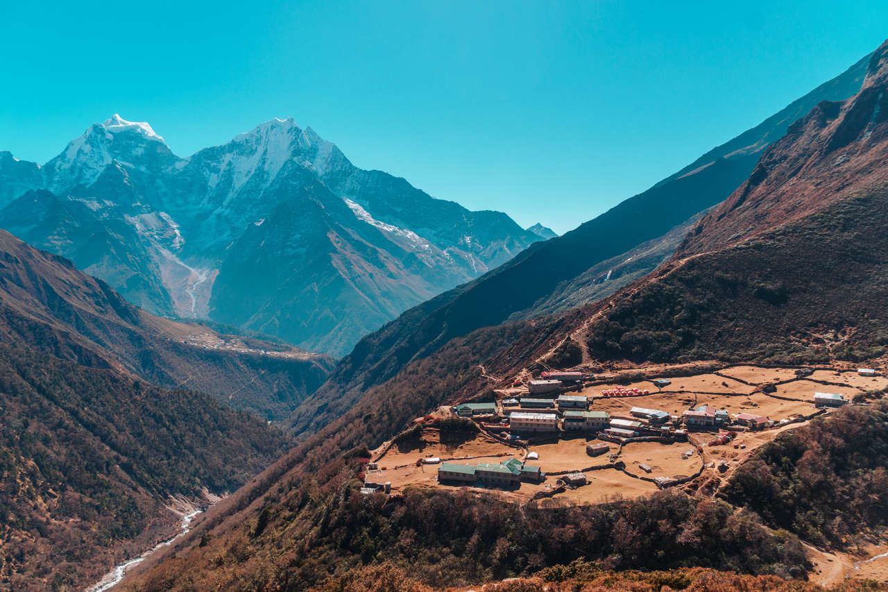
Tengboche is a small mountain village located at 3,867 meters above sea level. It is home to one of the largest Buddhist temples in the area, the Tengboche temple. Tenzing Norgay, one of the first people to ever summit Mt. Everest with Edmund Hillary, was born in this village. It is said that he was ordained as a monk here when he was young.
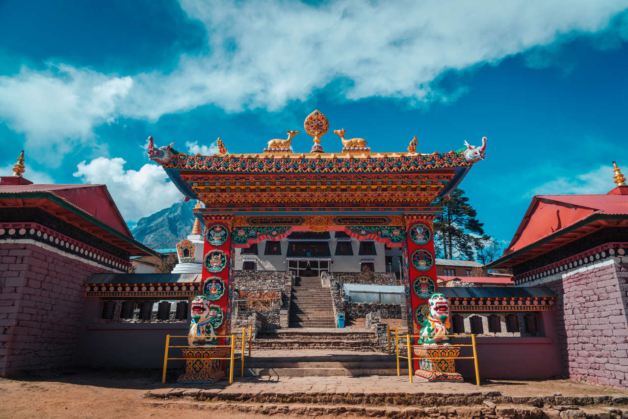
Due to its importance, there is no better place to build the largest monastery in the region than in Tengboche. Tengboche is located on top of a hill in an open area where one can see a sweeping panoramic view of the mountainscape of the Himalayas. From Tengboche, you can see all the well-known peaks: Tawache (6,495 meters), Everest (8,848 meters), Nuptse (7,861 meters), Lhotse (8,516 meters), Ama Dablam (6,170 meters), and Thamserku (6,608 meters), all in one quick glance.
I had quite a good time that day, arriving in Tengboche by lunchtime. As I settled into Tash Delek, my teahouse, I decided to go for a walk and check out the most popular tourist attraction in the village, Tengboche Monastery.
The monastery was built way back in 1924, but it had been renovated several times due to an earthquake in 1936 and a fire that broke out due to an electrical short circuit in 1989. Unfortunately, many of the precious old scriptures, murals, and wood carvings were destroyed during that devastating fire.
Thankfully, due to the influx of hikers and mountaineers in recent times, the temple has received many donations from all around the world, and it has been rebuilt back to its previous glory and filled with much newly commissioned artwork.
It is hard to describe how beautiful the temple is, so I am going to let a quote by John Hut, one of the first mountaineers to visit the monastery, describe the magnificence of Tengboche Temple.
Thyangboche must be one of the most beautiful places in the world. The height is well over 12,000 feet (3,600+ meters). The Monastery buildings stand upon a knoll at the end of a big spur, which is flung out across the direct axis of the Imja river. Surrounded by satellite dwellings, all quaintly constructed and oddly medieval in appearance, it provides a grandstand beyond comparison for the finest mountain scenery that I have ever seen, whether in the Himalaya or elsewhere.
Finding My People
Since it was quite a short day of trekking, all things considered, I decided to spend some time filming some of the footage I'd be using for my travel video, Never Everest.
As I was doing a handheld hyperlapse technique, where one would have to take one step, shoot a photo, and take another until reaching a set endpoint, and once done, I would combine all the photos into a moving timelapse or, as it is known in the industry, hyperlapse, I was approached by a curious Scottish couple who were bewildered by what I was doing.
I explained to them and showed them the result, and as we got to talking, we found out that we were staying at the same teahouse. Therefore, we decided to hang out for the rest of the evening.
The guy was a hilarious man, always making nasty jokes (fart jokes more so than anything 😂) and had a laugh that even the yak would run away from, and his wife, a blonde woman who was as fast to make jokes as to ridicule her husband's child-like demeanor. Both were in their late 30s to early 40s, and they were nothing but a delight to hang out with.
At the cozy dining room of Tash Delek, the scene from Lukla where big tour groups would come in occupied the entire place, and did not socialize with anyone, repeated itself again. Everyone was staying in their own group and none of them were willing to socialize with anyone outside of their own rag-tag team. It was a shame to see that one of the best parts about hiking had been reduced to this.
No matter, I had already found my people within the Scottish couple, as we continued to make each other laugh all night amidst the social isolation that had been happening in that teahouse.
We retreated to our bedrooms at about 10 PM after laughing our asses off the whole evening. Again, we did not say goodbye to each other because we knew we would meet again along the trail, and we did, several more times in the next few days.
Altitude Sickness at Four Thousand Meters and Beyond
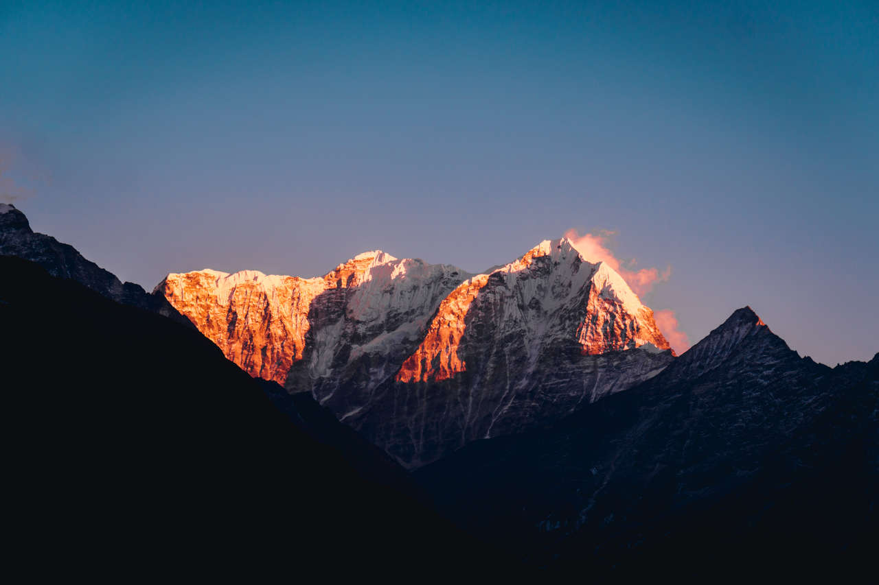
The next morning, as the sun shone upon the Ama Dablam peak, I sprang out of bed like every morning, had my morning coffee and an omelet fix, and set out as early as 7 AM.
The trail was still mostly under the shade, and as I was approaching the 4,000 meters elevation, the morning cold started to numb my face a little. Therefore, I was out in full winter gear, hiking towards Dingboche (4,410 meters) from Tengboche.
This was probably one of the shortest days of the entire journey. The trail climbed gradually as I continued to move northward. By the time I arrived in Dingboche, it was only around 11 AM. The entire walk took me about 3 hours, which is probably a good thing, as if you have done high-altitude hiking before, you would know the risk of catching AMS (Acute Mountain Sickness) if you are not careful.
The golden rule is not to gain more than 400 meters in elevation per day if you are already above 4,000 meters. You can hike up more in one day, but you will need to come back and sleep at an elevation no more than 400 meters from where you were sleeping before. Unless, of course, you spend a day acclimatizing, which I planned to do in Dingboche.
I have always followed that rule, and I never once get AMS, well now severely at least. The key is to take it slow and let your body do its own things. Do not rush through thinking that you are fine. The symptoms usually come at night when you are sleeping, and it can turn a healthy you the day before into a sack of potatoes the next day, so do not risk it.
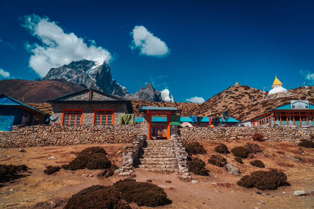
I decided to settle in at Snowlion Lodge just because they had a Belgian bakery attached to it. As I was already 5 days into my journey, I was seeking a little comfort and so, instead of going out for a hike, I ended up spending most of the day at the Belgian bakery eating cheesecakes and drinking a cup of Illy Italian coffee, not knowing that I was obliterating my budget until it was too late.
The 2 days I spent in Dingboche were pretty low-key, as I chose to rest instead of going out and hiking some short trails, as I did during my acclimatization day in Namche Bazar.
I did learn a lot about altitude sickness, though, since at this altitude, you are at a higher risk of getting one if you are not careful. The teahouse I was staying at gave me a leaflet provided by the HRA (Himalayan Rescue Association) explaining the symptoms, how it affects your body, and what to do if you or your friend have AMS.
Knowing the symptoms of AMS and tackling it early on could mean life or death to hikers. When you have severe AMS or, worst of all, HAPE (high-altitude pulmonary edema), where your lungs accumulate fluid over time impairing gas exchange, it may lead to respiratory system failure and death. In such cases, you won't even be able to walk yourself, as you will have trouble breathing and may experience coughing up blood.
It is said that if you take a person from sea level and drop them off at the top of Mt. Everest, they would die in a few minutes as their body fails to adapt in time. As you can see, AMS is no joke. It is best to listen to people's suggestions and spend a few days acclimatizing before heading to Everest Base Camp.
I spent that day and the next pondering about this as I cozied myself up in the bakery in Dingboche. Even though there was not much to do, almost to the point of boredom, I did welcome the change of pace.
Living in a city, and constantly traveling, can take its toll on our bodies and minds. By having a day of doing nothing but staring at the rumbling mountain peaks blowing off in jet streams, it was a change I really needed at the time.
After two nights in Dingboche, I was ready to move on. As I packed up, my frienemy, which was my 10kg backpack, I swung it up over my shoulders. Suddenly, pain shot up into my nociceptor (pain receptor) from my shoulder. I shrieked from the pain before dropping my backpack to the floor.
With my hands, I started trailing along the shoulder and found out that my shoulders were bruised from the excessive carrying of a backpack for many hours per day. There was nothing I could do but carry on, so I powered through the pain and continued hiking to the next village, Lobuche.
The Everest Disaster of 1996
Lobuche is a mountain settlement at an elevation of a whopping 4,940 meters above sea level. Coming from Dingboche, I had gained about 600 meters of elevation, which was a lot. However, with the help of an acclimatization day a day before, my body was able to adapt quite well to the altitude... or so I thought.
The trail out of Dingboche was relatively easy with a bit of up and down, but the moment I approached Dukla, the trail shot straight up so steeply that I was unable to see where it ended. Being at 4,600 meters above sea level in Dukla, breathing was becoming more like a chore.
For every step I took to climb that godforsaken hill, I had to breathe in to the maximum capacity my lungs could handle before breathing out and taking another step. Every step I took required both determination and a ton of tricks, telling myself that the top was around the corner, which it wasn't.
It took about one hour of doing that repeatedly before I arrived on a plateau. As I gazed up through sweat in my eyes, the multiple blurred triangular shapes in front of me were starting to come into focus. It was a stack of stones with prayer flags wrapped around it, and in the middle, there was a name plaque with 2 Sanskrit letters on the side, and a name in English that read "Scott Fischer". It was a memorial for climbers who had lost their lives in the Himalayas.
"Scott Fischer" is a name I have heard before. It is the name of a mountaineering guide, along with the name "Rob Hall", that appears frequently in one of my favorite non-fiction books of all time, Into Thin Air by Jon Krakauer.
The book Into Thin Air is a recounting story of the chilling Everest Disaster that happened in 1996 by Jon Krakauer, a writer on assignment from Outside Magazine who accompanied the team led by Rob Hall and another 11 people that perished on 10 - 11 May 1996 after attempting to summit Mt. Everest in 1996.
The book highlighted the event in gruesome detail, from all the small errors that may seem inconsequential, like a minor rivalry between Rob Hall and Scott Fischer's teams, to the bigger problems, like the unnecessary delay of rope-fixing, that all contributed to the perfect storm that resulted in 12 lives.
It is one of the best nonfiction books I've read, and it did a good job at shedding light on the people who were caught up in that situation, the things that went wrong in detail, and how hope and compassion played a role in the rescue mission that would have otherwise been forgotten.
As I arrived in Lobuche and retreated to the evening dining room of my teahouse, the same situation played out, with big tour groups occupying most of the available tables. I wasn't feeling very social that day, so I decided to reside in the small library corner they had at the teahouse.
I glanced along the small bookshelf to see if there would be any interesting book I could kill time with, and then I saw "Everest: Mountain without Mercy", a book that highlighted the same 1996 event but from a different perspective. My experience at the memorial in the afternoon, seeing all the names of those who had lost their lives in the Himalayas, flashed back in my mind once again.
In the "Into Thin Air" book by Jon Krakauer, there was a mention of the IMAX team that was shooting a documentary at the same time as the disaster. When the disaster happened, they decided to drop everything and become part of the rescue team, and this book was their recollection of the event, which gave me a perspective I did not know about before.
Together with its detailed documentation of the courageous rescue team, the book also came with stunning photos from the mountain and a detailed explanation of the mountain's features that I would be observing with my own eyes the next day.
The more I read about it, the more I feel both humbled and excited at the prospect of reaching Everest Base Camp the next day and seeing all the infamous mountain features like the forever-moving Khumbu Icefall that I've been reading about for the longest time.
That night, I retreated to my bedroom at around 10 PM, and as I tried to sleep, I started to feel a little lightheaded. I slept anyway, but I woke up many times that night, finding myself drinking so much more water than I used to as my throat became dry and sore. My runny nose had become incredibly intolerable. I powered through it and tried to get as much rest as I could before the big day.
As it turned out, this would be the beginning of the many terrible nights I would have for many days to come. I was starting to see how sleeping at such an altitude of 4,000m+ was taking a toll on my body, especially my respiratory system. The dry air of the Himalayas that I had been breathing in and out for the past 6 days was the reason why I would come to learn about the dreaded Khumbu Cough, a symptom of prolonged coughing caused by the low humidity and temperatures associated with high altitudes.
The Day I Reached Everest Base Camp
As I dragged my body out of bed from a half-awake, half-asleep night at almost 5,000m above sea level, I had breakfast and slowly packed my bag as usual. But this time, the heaviness of my backpack was no longer an issue.
It either was that my body was so used to pain that it became numb, or the pain was subsided by all the adrenaline rushing in from the thought of finally reaching Everest Base Camp. Either way, I was already tackling the trail by 8 AM.
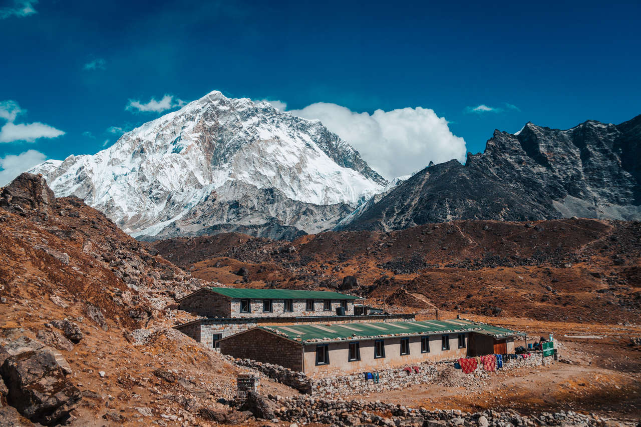
Driven by my excitement, it took me only 3 hours to climb to the final frontier settlement before Everest Base Camp, where I'd be spending the night: Gorakshep. Standing at 5,164m above sea level, it was so cold in Gorakshep that there was no running water. The only way to get water for performing simple tasks like brushing your teeth was to buy bottled water.
No matter, I had my eye set on reaching Everest Base Camp before the day ended, and so I left most of the unnecessary stuff at my teahouse and continued onward to Everest Base Camp.
Not a single vegetation did I see, as I looked around the vast gravel trail on my way to Everest Base Camp. As I approached the trailhead, I noticed a small bright orange directional sign with edges painted in bright red. It said "Way to Everest. B. C." and had a red arrow pointing to the right. That was the moment when I realized I had finally made it. After 6 days of nonstop hiking, I was about to achieve a lifelong goal I had set ages ago. It was finally happening.
The trail consisted of a lot of ups and downs, but nothing would stop me from reaching the base camp now. As I hiked up slowly but surely, the sight of the infamous Khumbu Ice Fall came into view. One of the deadliest features of Mt. Everest, the Khumbu Ice Fall is a forever-moving glacier that moves at such speed that large crevasses can open and seracs can collapse at any moment with little warning.
This deadly feature of Mt. Everest is the first obstacle many mountaineers have to go through to reach the top of the world. Seeing it with my own eyes left me extremely humbled by mother nature and also made me respect those who had managed to navigate it successfully.
After seeing the Khumbu Ice Fall, it was only about 30 minutes until I arrived at the Everest Base Camp. Since it was November, there was no camp per se, as most people who attempt to summit Mt. Everest usually do it in Spring, not Autumn. The only things that signified that I was at the Everest Base Camp were the pile of rocks covered in colorful prayer flags and a small black plaque that said "Everest Base Camp - 5364 masl."
As I stood at the Camp, I looked up and had a hard time recognizing which peak was Mt. Everest. As more people arrived at the camp, we all asked the same question until a Mexican man from Saltillo pointed to the black diamond peak, tucked away behind the towering Nuptse, Lhotse, and Hillary Peak.
As each of us took turns taking photos of Everest Base Camp and the stunning mountain peaks that surrounded us, we made our way back slowly to Gorakshep, feeling accomplished. But deep down, we all knew that the hard part had yet to come.
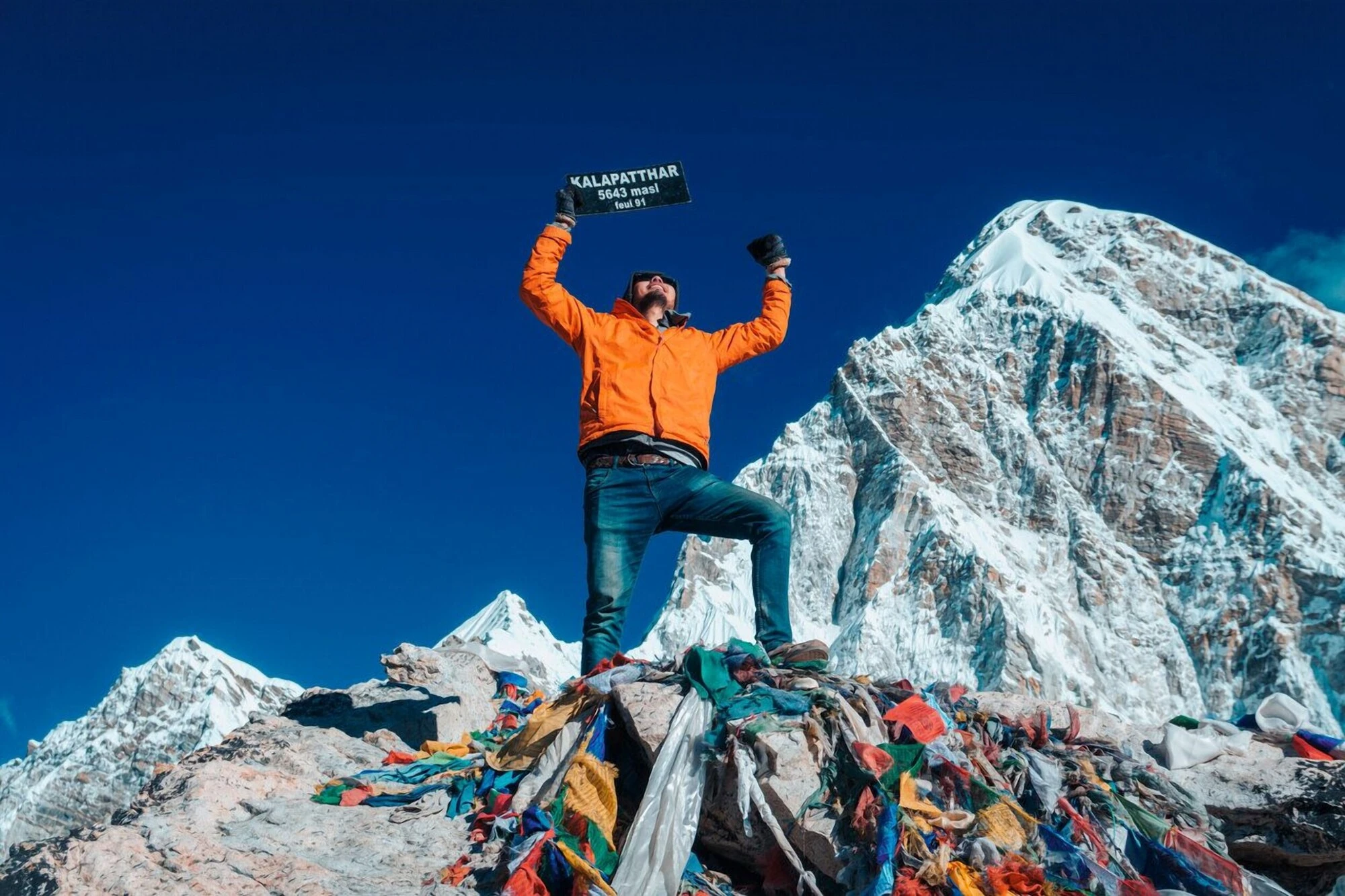
Near Gorakshep, there is another mountain called Kala Patthar, a somewhat ugly giant dune full of huge boulders and rocks at 5,550m - the highest point on the Everest Base Camp trail. This would give me a better vantage point of Mt. Everest, Mt. Lhotse, and Mt. Nuptse, as well as a panoramic view of the landscape around Everest Base Camp. It is the mountain I would be tackling first thing the next morning.
Sleeping at Gorakshep was not a pleasant experience, to say the least. The altitude made it hard to breathe normally, and with the temperature as low as -15°C, you won't be able to sleep without wearing all your jackets and burying your body under thick layers of blankets. However, when you do that, you won't be able to breathe that dry air properly.
My night was plagued with an extremely dry cough, feeling hot and cold, and constantly moving around trying to fall back to sleep every time. It was a waking nightmare as I tried my best to sleep that night in Gorakshep, and as expected, the runny nose finally made its way to my throat, causing me to cough constantly – a sign of the dreaded Khumbu Cough that would eventually plague me for the rest of my time in Nepal and a few months after.
The Highest I Had Ever Been
Everest Base Camp was done, but the hardest part of this whole journey had yet to come. There were still Gokyo Lakes and this Kala Patthar mountain that I had to climb that day. Besides, the fact that I still had to go back to Lukla meant that I did not feel like relaxing quite yet.
Kala Patthar is a popular side-trek to reach the highest point on the trail, standing at 5,550 meters above sea level. This would be the highest I had ever been so far. Previously, the highest I had ever been was when I summited Nevado Mateo, a 5,200-meter snow-capped peak in Peru, and I did it with full mountaineering gear.
This time, it was different. As my body deteriorated the more I slept at this altitude, it became harder for me to breathe and continue my journey. I felt completely fine when I woke up and hit the trail. As the trail progressed from Gorakshep, it shot up so steeply that you couldn't even see where the summit was. Plateau after plateau, as I hiked slowly up the dusty trail of Kala Patthar, I started to wonder if the trail would ever end.
The trail wasn't particularly inspiring as it consisted of only large rocks and boulders, and all you could see was desolation all around with zero vegetation. However, the moment I arrived at the summit and gazed up at the elusive Mt. Everest, all the sweat and tiredness from 7 days of hiking dissipated. It was the moment I saw the true scale of Mt. Everest.
The black diamond peak, with the jetstream blowing off its peak, pierced the sky, towering over all its neighbors. There was no place in the world where you could see such a formidable force of nature like this. From seeing the true scale of the Khumbu Ice Fall to the intimidating South Face of Mt. Everest, this was the moment I had been waiting for. It was the feeling of accomplishment from getting there all by myself and the humbleness that came with standing among these mountain beasts.
This was the highest point I had ever stood on, at 5,550 meters above sea level, and it was an accomplishment of which I was very proud. Even though I would have loved to cherish that rewarding feeling a little longer, I had to continue on. I had to continue onward to Gokyo Lakes, with another 4 hours of trekking ahead of me to Dzongla.
I rushed down the trail and to my surprise, I was at Gorakshep a little earlier than I thought. It took me almost 2 hours to get up that trail, but I managed to do it in just 45 minutes on my way down. That's how steep the trail to Kala Patthar was.
Remember the middle-aged Scottish couple I met in Tengboche? I accidentally met them again on my way down from Kala Patthar as they were making their way up. Being around them always made me laugh, and it was the case again here as well, as they called me "the crazy Thai guy with jeans and improper shoes" 😂 and I proudly accepted that title. We tried exchanging our contact information, as they were curious to see the Never Everest video I would be making of the trip. Unfortunately, I was unable to find them on Facebook, and I have not seen them ever since.
Such is the way of life for a traveler that I came to truly loathe. The number of all the good people you meet along the way who slip through your fingers is an unfortunate byproduct of the lifestyle I chose to live by. It was a sacrifice I willingly made back in 2012; fast forward to this day, I am not so sure if I truly enjoy the "saying goodbye and never meeting again" part as much.
As I packed my stuff up at Gorakshep and prepared to make my way back to Lobuche before lunch, I realized that I had one other pressing problem other than my deteriorating cough: I was running out of money. Days of splurging on Italian coffee and cheesecakes at Dingboche had finally caught up to me.
I realized that I had the budget left only for the 3 nights of accommodation and a few Rupees spared for food, which was by far the most expensive part of trekking in Nepal. There is an ATM at Namche Bazar that sometimes works, but that was still 5 days away, and I would not be able to reach it in time at my current speed.
The anxiety of running out of money in a foreign land, which had happened to me on several occasions (Iran came to mind), was starting to creep up on me. However, I had a more pressing issue at hand: I had to make it to Dzongla first. So, I decided to brush off that anxiety for the time being and press on.
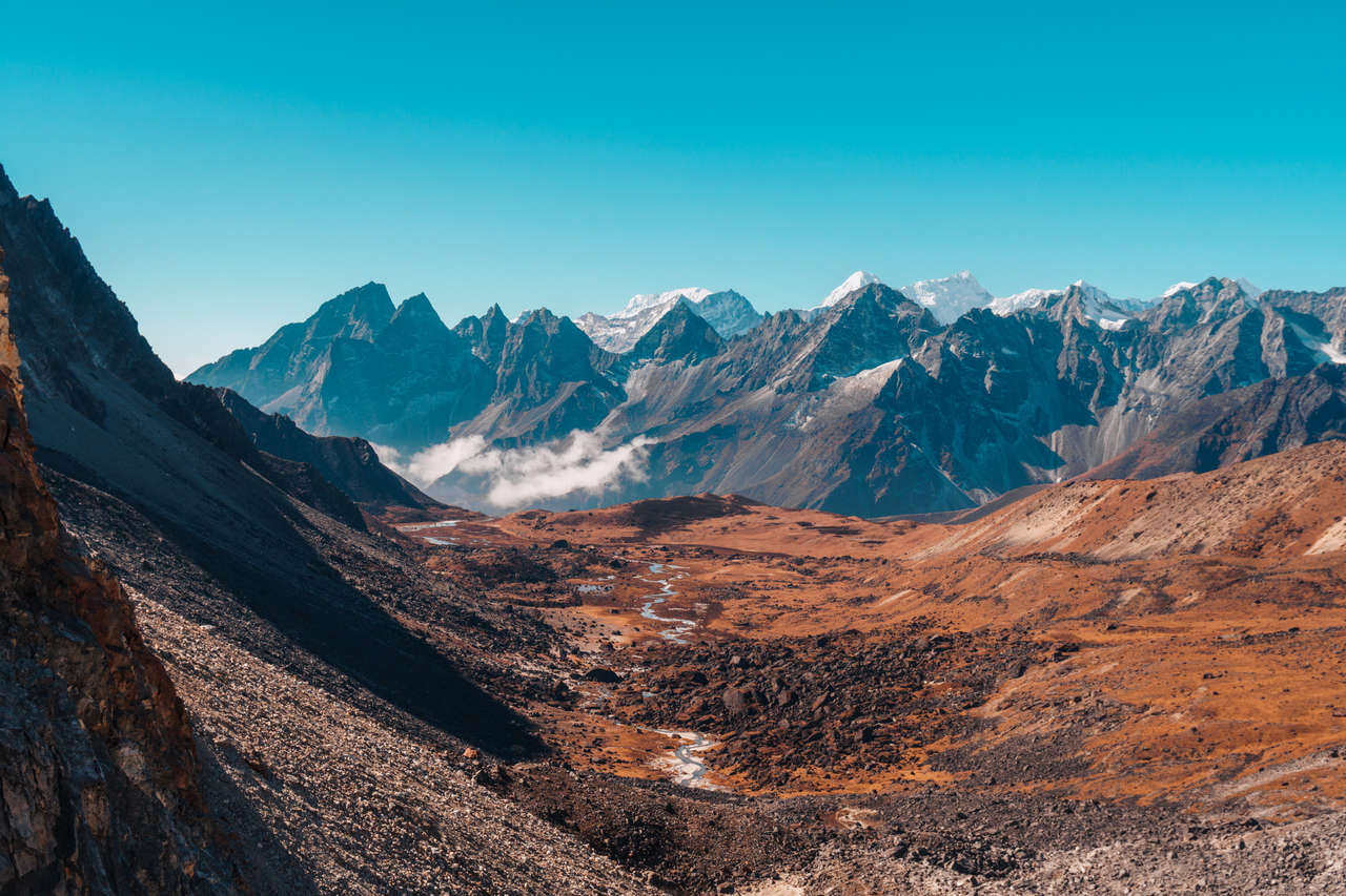
It took me around 2 hours to get back to Lobuche. I ate a quick dish of fried momos for lunch to save costs, and continued on down. Right before arriving back at the memorial I saw a few days ago, the trail forked to the right. Instead of heading back to Dingboche, I turned right onto the forked trail and headed towards Dzongla (4,830 meters), where I would be spending the night.
It was around mid-afternoon when I bore the weight of the sun's heat on my back while walking along a tiny cliffside trail. The trail from Lobuche to Dzongla had stopped me more often than I would like to admit. The sweeping panoramic view of the valley that I had trekked through a few days ago seemed so small from up here. It was probably one of the prettiest trails I had seen so far.
The trail was smaller than usual as it hugged along a slope of the mountainside. Most people often go for Everest Base Camp and they called it a day, so not as many people take this trail, and it was apparent as I was alone most of the time as I leisurely hiked through the valley, taking my time to enjoy the scenery for once.
The trail was longer than I anticipated, and I was taking it a little too leisurely as the sun tucked behind the mountain and the evening clouds started rolling into the valley. With clouds coming in, covering the clear blue sky I was lucky to have that day, the temperature started to sharply drop, and my Khumbu cough started to flare up.
At around 4 PM, the fog completely covered the trail, and I had only around 50 meters of visibility. As I approached the last hill before going up to Dzongla, I found it harder and harder to hike at a steady speed. I started coughing dryly every few minutes.
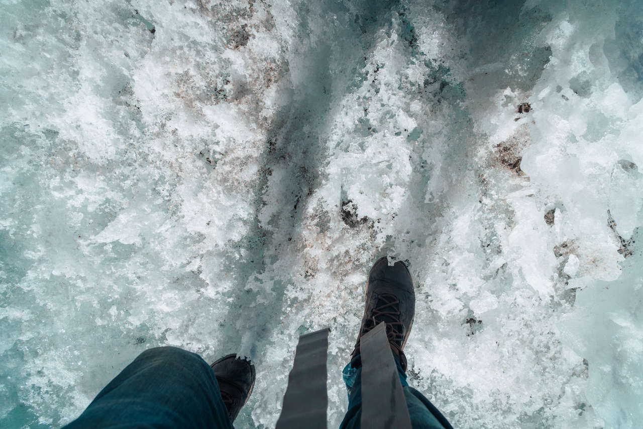
I eventually arrived at the teahouse in Dzongla at around 5 PM, in a somewhat confusing state, as I had somehow dropped my sunglasses somewhere during the Khumbu cough episode I experienced before arriving in the village. The next day was going to be one of the hardest days of this journey, as I was about to tackle Chola Pass (5,420 meters), one of the Three Passes. Additionally, part of this hike would involve walking on a melting glacier without a crampon.
Due to this particular feature of the trail, I was told to wake up at 4:30 AM the next day to start the hike by 5 AM, ensuring that I would arrive at the glacier before 9 AM to cross it safely.
If you think walking on a glacier without crampons was already challenging enough, try walking on it when the sun is fully out, melting the very ground you are trying to walk on. Apparently, as the day progresses, it becomes even harder for me to hike the icy glacier because the ice starts melting, making it even more technical.
I took that suggestion to heart and went straight to bed at 9 PM after spending my dwindling budget on a small dinner that day. Ever since my sleeping pattern was disrupted in Lobuche, I have been unable to have a good night's sleep. The nights often consist of me waking up every few hours, coughing my lungs out and swinging my arms around confusingly in the dark, trying to find my water.
I eventually powered through the night as the sound of people waking shook the entire wooden structure of the teahouse. The wind had finally calmed down, and I was happy to see that the sky was clear again. It was time to tackle the Chola Pass and its icy glacier.
Standing on Thin Ice
I was out of Dzongla even before sunrise. The gripping, negative temperature of the Himalayas had me scrambling for more layers as I opened the front door of the teahouse into the darkness. It was the earliest I had ever woken up on this trip.
The trail was empty, the mountain was quiet, and only the dim lights of people preparing for the day in teahouses reminded me of life in this desolate land. The trail begins on a flat plain between 2 valleys, and for about an hour or so, it was a nice morning stroll.
All of a sudden, the trail shot up against a cliff as it ended on a mountainside. As I searched for the next trail to continue, I realized that there was no trail. I had to climb the boulders up to the top of the plateau with my bare hands.
The problem with a trail like this was that even though it is shorter, it was hard for me to pace myself when climbing up boulders with my hands than to simply hike up a trail. With my worsening coughs, I really felt it this time. I had to stop every 5 minutes to take a break as I coughed violently and breathed before I could continue on.
The boulder climbing proved to be one of the hardest and most tiring parts of the entire trail for me, as my breathing was constantly disrupted while I scrambled my way up. It took about an hour and a whole lot of stopping to reach the plateau where the next challenge began.
By 9 AM, as planned, I had finally arrived at the infamous icy glacier section towards Chola Pass. The entire length of the glacier was not that long, but due to the fact that I had to calculate and plan every step I took, it was more nerve-wracking than anything else.
The glacier itself consisted of jagged surfaces partitioned out with smooth icy surfaces in between. It was the jagged part that I would have to put my feet on and avoid the smooth icy surface at all costs. Since the surface was not divided equally between the two types of surface, I would have to plan my route even before I took my first step onto the ice.
It was this decision-making and the responsibility you had for your own safety that put me on alert mode, draining all my energy away. The cough subsided, for the time being, thank goodness, but I was so focused on every step I took that I had little time to actually enjoy the trail.
I put my feet on the jagged part of the glacier at a diagonal, drilling my feet onto the fragile ice to create enough friction for me to move my other feet onto the next surface. All the while, I calculated the best possible route to take, ensuring that I would not get stuck in a bad place.
This was going on in my mind for 30 minutes, and the slope of the trail toward Chola Pass didn't help either. Thankfully, when I arrived, there was a small group of Dutch hikers led by a very experienced Sherpa who was leading the way, and so, unknown to the hikers, I stuck with them and followed their route to the tee.
By the time I arrived at Chola Pass, I was too exhausted to even enjoy the reward of the vantage point, which I often do. The cough came back again as the wind was in full force the moment I reached the Pass.
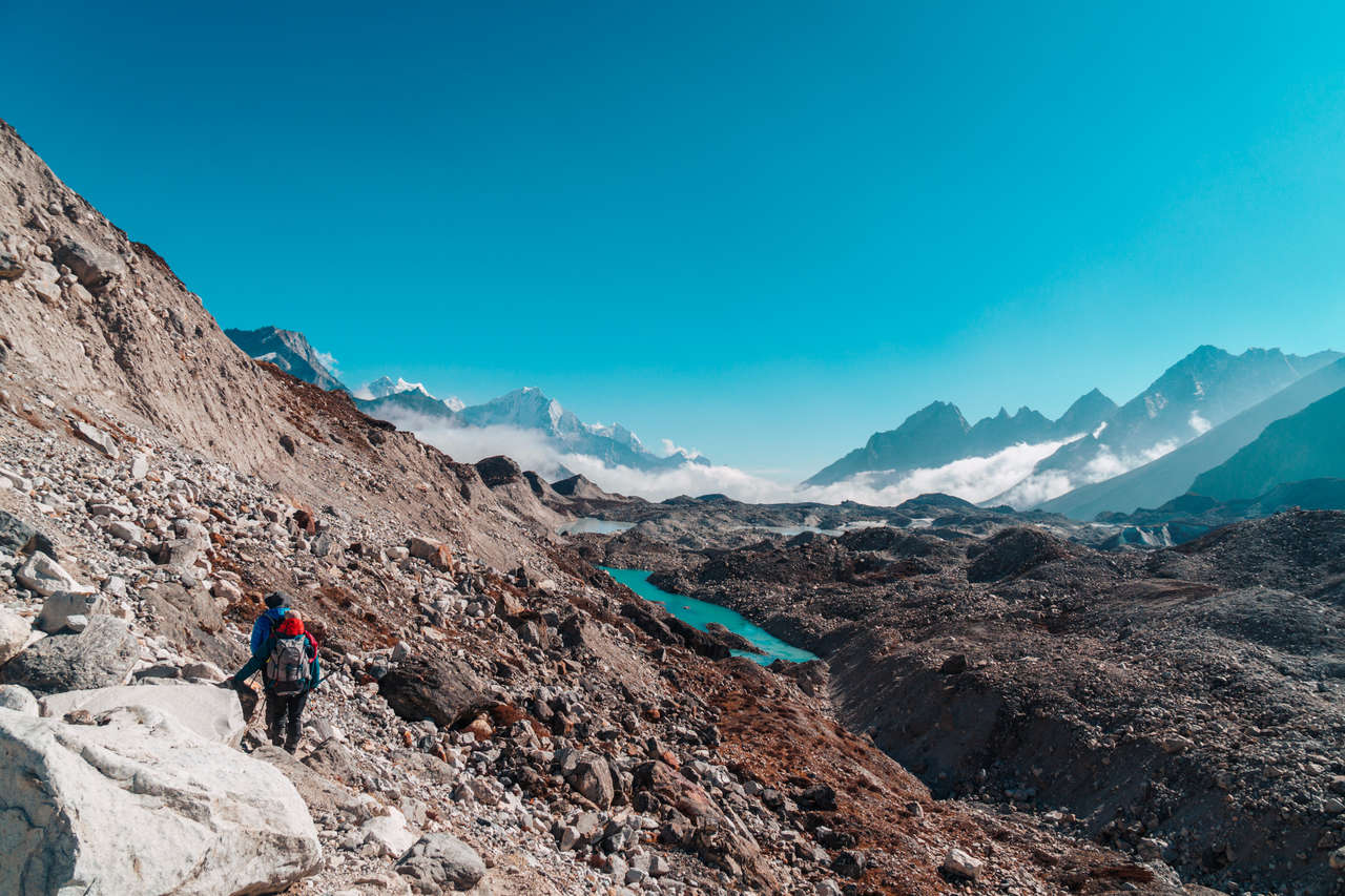
The scenery was hard to complain about, though, as I could see the glacier I had just conquered a minute ago in its true scale from one side, and, as I came to realize later, the Gokyo Glacier, where I would have to go next, from afar on the other side of the Pass.
I spent only a few minutes up on Chola Pass as it got too cold for me, and my coughs and runny nose weren't helping. So, I started hiking down the trail into an opening where the trail became mostly linear until Dragnag, a village where I would have to stop for lunch.
It was a simple stroll, but it was long. Due to the fact that my energy was spent trying not to fall at the glacier before Chola Pass (and I succeeded), the simplest part of the trail had me on my knees. It took me about 1.5 hours before I arrived at Dragnag, pretty baked from the intense rays of the sun, all covered in sweat. I devoured another dish of steam momo before setting out on the last leg of the day, to Gokyo Lakes.
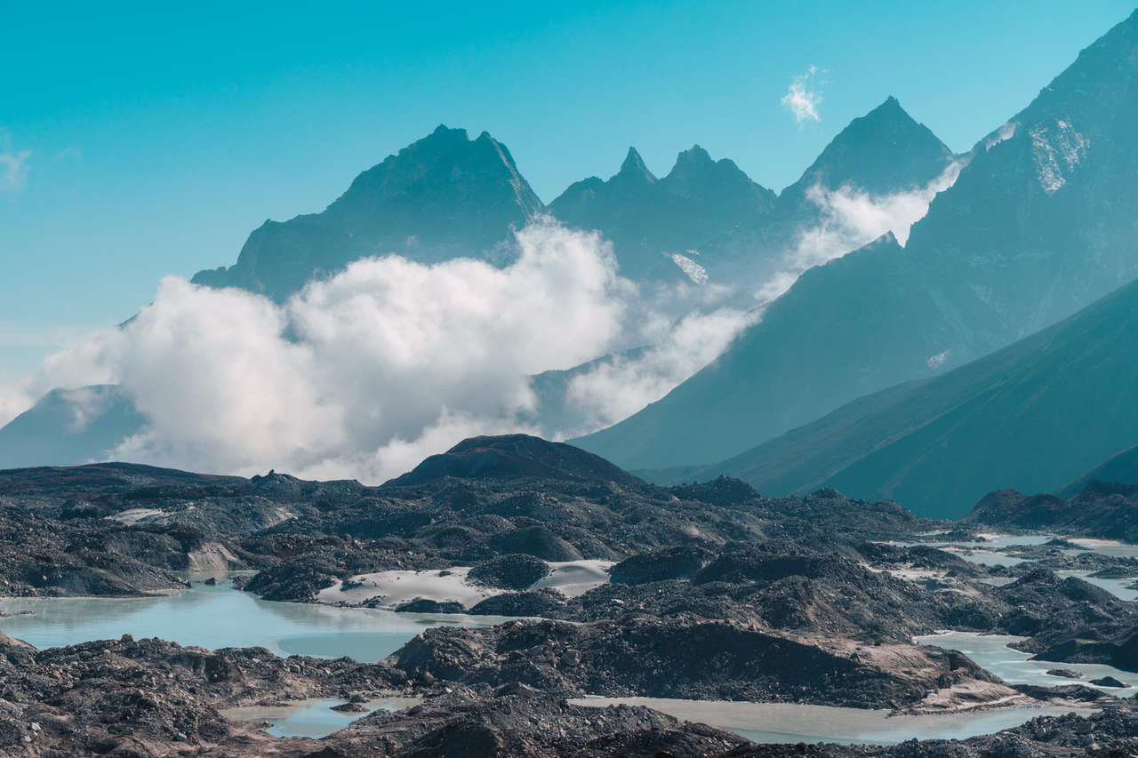
The thing that was between me and the comfortable bed and the beautiful view of the lake at Gokyo Village was the Ngozumpa Glacier, a 36km-long melting glacier considered to be the longest in the Himalayas.
Thankfully, we do not have to traverse the entire length, but just cross its dry glacier stream that looked like a rocky riverbed to reach Gokyo village. However, this was already challenging in itself for someone who was completely drained a few hours before and currently suffering from the Khumbu Cough, such as myself.
The trail crossing the glacier consisted of lots of ups and downs on a dusty, slippery gravel path that does not resemble a well-trodden trail, like the one I saw leading up to Everest Base Camp.
It was difficult, not because of its technicality, but because of the knowledge that the village is right there in front of me, and yet I had to traverse the dreaded terrain before climbing out of this trench. It was like teasing hungry people with food but not giving it to them. It was torture!
As I walked along the glacier, trying to figure out where the actual trail was, a light reflecting from a person's blonde hair caught my eye. As we both moved closer, we started to notice each other. It was the German girl I met in Namche Bazar many moons ago, who warned me about the cold in the mountains!
"Fancy meeting you here!" I shouted, as the sound echoed throughout the valley, as we limped and hobbled towards each other. "I knew I would meet you somewhere along the trail", I told her excitedly, as we exchanged a brief pleasantry before she told me about her journey.
Apparently, she got really sick right after Namche Bazaar but was still determined to complete the Three Passes route, so she continued her journey slowly but firmly, setting her eyes on completing it within 2 weeks. She was doing the trail clockwise, whereas I was doing it counter-clockwise, hence why we stumbled upon each other here, in this desolate trench.
She was still surprised by my dress code with jeans and improper shoes but admired my resilience. I also admired her determination and how she continued to excel against all odds. We said "See you later" again this time, hoping we might meet again in Namche Bazar or in Thamel, the backpacking street in Kathmandu. I never saw her again and to this day, I still do not know her name. Such is the life of a traveler.
By about 4 PM, I arrived at Gokyo Village, and as I was scrambling to find a lodge, I ended up at a small teahouse located right by Gokyo's third lake called Dudh Pokhari, one of the most stunning emerald-colored alpine lakes I had ever seen. After I settled into my teahouse, my tiredness swept away as I looked on at the glistening water of the Himalayan lake in awe.
Gokyo Lakes and Gokyo Ri
Gokyo Lakes is one of the highest lake systems in the world, and as the name implies, it is a collection of 19 freshwater lakes over an area of 196.2 ha lying between 4,600 meters to 5,100 meters above sea level.
Gokyo village, where I was staying for 2 nights, is a small tourism-reliant settlement with an elevation of 4,790 meters. It is located at the foot of Gokyo Ri, a 5,357-meter-high mountain that, in my opinion, offers one of the best views of Mt. Everest. This is where I would be tackling first thing in the morning.
Like any other day in the Himalayas, I slept pretty horribly that night, struggling to get out of bed for a while until I conjured up all my power to go out and start hiking Gokyo Ri.
Gokyo Ri, just like Kala Patthar, is not the prettiest mountain around, but it does give us an amazing vantage point of Mt. Everest, the Ngozumpa Glacier, and a wonderful view of the 3rd Gokyo Lake.
The trail began along the shore of the lake before zig-zagging up the mountain. From there on, it was a 2-hour non-stop steep climb which, on a normal day, I would have no trouble hiking. However, due to the horrible nights of sleep and the worsening cough, it took me almost 3 hours to reach the summit.
I would hike for about 20 minutes before I started coughing violently, so much that I had to rest, take a deep breath, and continue on slowly. This continued to happen for 3 hours during my ascent. I almost gave up at one point when I reached what I thought was a summit, but it was only a small flat area before the mountain continued on even higher.
On Giving Up
I met a Spanish girl who was sitting there, out of breath, yet still content as she looked out to the landscape, absorbing the stunning view. From that spot, I could see the 3rd Gokyo Lake as well as the 2nd Gokyo Lake in the distance. I asked her how far the summit was, and she didn't know. Apparently, she had already given up and accepted the view as she saw it.
I sat with her for a while, contemplating that I should give up as well and just enjoy the view. My cough was getting worse to the point that my chest started to hurt a little from excessively coughing out my lungs. The more I thought about giving up, the more it reminded me of the time I was in Pedro de Atacama in Chile years ago.
It was summer 2016 in Chile, and I had just come from a tiring 4-day trip traveling around Salar de Uyuni, the largest salt flat in the world located in Bolivia. I remember feeling exhausted from that trip, so much so that when I arrived in the Atacama desert, I didn't bother to do anything there other than rest for the next 4 days. I thought that the scenery around the Atacama desert was probably the same as in Bolivia.
Several days passed, and my journey in Chile continued down south towards Santiago where I would be meeting my friends for Thanksgiving (shout out to Martina and Fatima for hosting me!). They started showing me photos from their trip in the Atacama desert, and I was completely blown away by the beautiful moon-like landscapes. However, I felt extreme guilt for being there, acting like a lazy ass, and ended up not doing anything.
That experience of failure swept through me as I was catching my breath atop a mountain in the Himalayas, overlooking the greenest lake I had ever seen in my life. "I would not repeat those same mistakes again", I told myself before standing up, turning my back on the view, and continuing onward towards the top of Gokyo Ri.
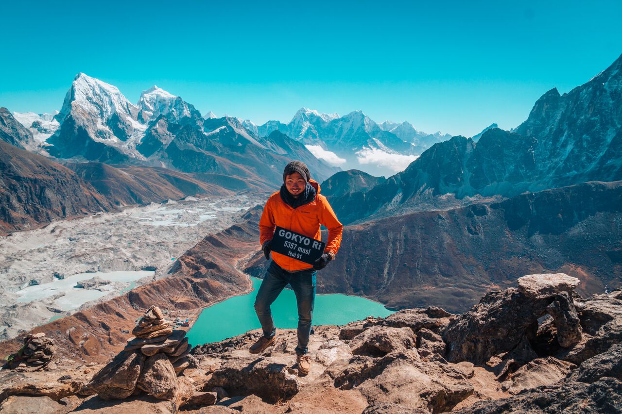
After 3 hours of scrambling my way up the rocky trail of Gokyo Ri, I looked up and all of a sudden, there was no more trail to climb. Right near me, I saw the stone stacking pyramid and a black plaque that said: "Gokyo Ri - 5357 masi". That was when I realized I had finally reached the summit!
The moment I arrived at the summit, I was as calm as the sky that day. Against all odds, I was able to drag myself up to the last high-altitude mountain I'd be hiking on this trip. The last obstacle was finally conquered by my very own ability, and nothing could take me away from that.
As I looked on at all the Himalayan mountains surrounding me, while the prayer flags flapped violently along with the gust, a familiar black diamond-shaped peak greeted me once again.
From the summit, I was able to see the true scale of Mt. Everest compared to the other 8,000-meter peaks like Lhotse, Makalu, and Cho Oyu. "So this is the top of the world", I told myself as I stared at Mt. Everest in wonder. A peak that literally towers over every single peak in the world. The top of the world was never more apparent to me than now.
I was up there for a good hour, taking a ton of photos before I started heading back down to Gokyo Village. It only took me an hour to get down, and as I stumbled my way into my room at the teahouse, I collapsed onto my bed and napped for the rest of the day.
Running Out of Money
I knew I was almost at the limit that day, but there was one more obstacle that would further push me almost over the edge. It was the fact that I no longer had enough money to stay another night anywhere else or to eat a proper meal, and the closest ATM was in Namche Bazar, which was 16.1km away.
With that in mind, I decided to rely on what was left of my snack stash for dinner that day and ended the day as early as I could so that I could tackle the longest, hardest day of all: the day I had to do a 2-day hike in one day from Gokyo Lakes to Namche Bazar.
Even though there was a long day ahead of me, I was thrilled to finally get down from the 4000+ altitude and experience what a lung full of air felt like again... and a nice warm shower would be nice too after 10 days of not showering. 😆
I started my day as early as 7 AM, decided to waste no time, and hit the trail immediately while also eating one of the last granola bars I had left with me. The nasty Khumbu coughs were still plaguing me throughout, but I had no choice but to continue on.
I progressed really well in the morning as I literally ran down many portions of the trail to save time. The cough did not bother me as much, as I continued to hydrate myself constantly while making leeway towards Dole, a small settlement where I was supposed to stay overnight.
It took me around 4 hours to get to Dole, which I thought was pretty good timing, arriving there by 11 PM. This left me with a good 6-hour window before sundown to reach Namche Bazar.
As oxygen rushed through my lungs with more concentration than I had ever experienced in the past 5 days, and considering my great progress up to that point, I thought to myself that it was going to be easier from there. Oh, how wrong I was.
Up to that point, the trail I was hiking on was mostly descending, but what I did not anticipate was the fact that in order to get to Namche Bazar from Dole, I had to go through Mong Village, which is located on top of a mountain where one had to climb straight up for 2 hours.
I did not realize that until the trail started to confusingly go up after several hours of going down. As my cough had gotten worse and worse, I was unable to hike up more than 10 minutes before I started coughing again. The trail right before Mong was one of the hardest parts of the entire day. The more I hiked up, the steeper it got, with no sign of the village.
As the clock ticked from 1 PM to 2 PM, I was still ascending the trail very slowly, stopping every few minutes to cough, catch my breath, and force myself to take another step. By that point, my snack had run out, and I no longer had any money left, so even when I reached the Mong Village, I did not have the luxury to stop and spend the night.
It was not until 3 PM when I arrived at the Mong Village, all covered in sweat, and my mouth as dry as the dry soil suffering from drought. My body was at its limit; I could feel the pain coming from my shoulders again as I hauled around my 10kg backpack. Scratches and wounds were all over my body after several days in the mountains. My muscle mass was obliterated, and my body covered in dirt as I sat by the plateau overlooking the valley I had just climbed that day.
Two more hours to go until Namche Bazar, and as the sun was about to set in a few hours, I had no time to waste. I grabbed my backpack and continued onward from Mong Village to Namche Bazar. The trail continued downhill with a few uphill slopes that made me curse every time I had to climb one. My body was no longer functioning as it used to, as every few steps I took, I had to cough.
At around 5 PM, I approached the mountain-side trail where I had seen Mt. Everest for the first time more than a week before. The sun was already behind the mountain, and as I slowly walked up the slope to reach Namche Bazar, I looked up and saw the last light of that day shining on one of the snow-capped peaks in front of a perfectly purple evening sky. That was when I arrived in Namche Bazar.
I limped and hobbled my way into Namche Bazar as my surroundings turned pitch black. It was 6 PM, and I finally made it to Namche Bazar where I could finally eat whatever I wanted and stay however long I wanted. I was no longer bound to my non-existent budget anymore. I was finally free.
In the dark, I scrambled my way to find Khumbu Lodge, the teahouse where I stayed last time, and the moment I entered the teahouse, the owner remembered and greeted me with open arms. After exchanging words of congratulations, I ordered the most Western food I could imagine - a hamburger - and devoured it like a hyena storming its prey. I had finally overcome my last obstacle.
Getting Out of the Mountain in One Piece
As my condition deteriorated, despite being at a lower elevation, I decided to spend 2 days resting in Namche Bazar before completing the last leg of my journey to Lukla and back. To ensure I stuck to this goal, I decided to book a flight from Lukla to Kathmandu in 2 days. It was the only way for me to motivate myself to go to Lukla; otherwise, I would have stayed in the comfort of Khumbu Lodge forever.
In those 2 days, I withdrew money from an ATM close by. Thank goodness it worked, as I had tried at least 2 others that didn't work. Finally, I ate like a human being and showered after almost 15 days in the mountains. I also had the time to actually enjoy the beauty of the Himalayas. As I strolled around the village, I tried to recollect my experience, as I often do after a memorable trip like this.
I also spent this time visiting the doctors at one of the altitude-specialized community-run clinics, as they prescribed me several medicines, both pills and liquid, to soothe the pain in my throat from coughing my heart out in the past week. The local doctor told me that I was breathing through my mouth way too often while hiking, and since the air was extremely dry up at this altitude, I was developing a nasty case of Khumbu Cough. She recommended that I get a buff next time I hiked in such altitude again.
I took that suggestion to heart and bought a buff with the Himalayan topography map pattern from the shop next door as a little souvenir to remind myself of this once-in-a-lifetime journey.
After two days of self-discovery and developing newfound strength from my experience, I decided to say goodbye to the owner of the lodge one last time and continue my journey down to Lukla.
This journey, which anyone could have done in 6 hours, took me almost 8 hours because my cough had gotten to the point where I was unable to move more than 5 steps before coughing violently. The more I coughed, the more my chest hurt, and the harder it was for me to regulate my breath as I hiked.
The cloud that rolled in that day, causing many flights to and from Lukla to be canceled, also did not help with my coughing. Due to the clouds, it was also raining lightly as I was on my way to Lukla, which made my cough and runny nose even worse than before.
My body reached its limit when I had to climb up the last hill before arriving at Lukla at around 5 PM. I was on my last leg when I stumbled into my lodge and completely passed out on my bed before flying back to Kathmandu the next day, completing the entirety of this wonderful and challenging journey of mine.
The Why of It All
To be honest with you, I looked like sh*t when I hobbled into Lukla that day. I was completely soaked from head to toe, my mouth was extremely dry, my chest and back were hurting unbearably, and I couldn't feel my legs or my knees.
Even when I was back home, I realized that I had lost over 7kg. I couldn't walk up or down stairs without holding the rail for days afterward, and I continued to cough violently for many weeks after.
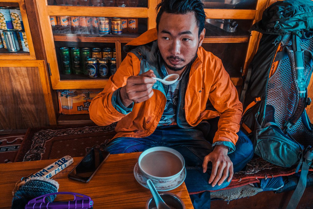
I was a complete mess by the end of this trip , but I was happy. I was happy to be able to experience the mountains in such a real and authentic way that no future trip had ever surpassed. I was happy to be able to observe how my body reacted in such a stressful situation, how it handled itself no matter what Mother Nature threw at it, and how I mentally handled obstacles like illnesses and running out of money. It had taught me to be calm, to address the situation as it is, and to live through it all vigorously.
Yes, I learned a lot about the mountain on this trip, but more so about myself, the things I was capable of, and what I was able to handle as my age dipped towards the big 3 on this journey. They said that after 30, it would be downhill from here on out, but I beg to differ.
The future beyond this point may be full of uncertainties, but with this experience and knowledge I gained about myself, about the nature of the world, and how our problems mean absolutely nothing in the scheme of things, all under my belt, I am sure as hell going to try to live the best life I can lead, to work with what I have, and to try my very best to stay true to myself until the very end.
My crippling body would heal in no time, but this experience and the things I'd learned about myself, about life, and about others sharing this same world with me, no one can ever take that away.
The Himalayas have a knack for changing people, stripping us naked, revealing our own vulnerability, who we really are, and forcing us to stare at it until we accept our condition.
And that is why I will always put myself through hell to climb the Himalayas. The mountain is free of prejudice and the artificial and societal pressures ("norms") we put ourselves through every day while navigating this modern life of ours.
Being reconnected with Mother Nature is the only way to remind oneself to hit that break, look back, and realize that there is so much more to life than what was ingrained in our society, and I could not think of a better place to lose oneself in than the Himalayas.
I have always wanted to return to writing about travel stories, what I had learned on the road, and the experiences I had encountered throughout my time traveling the world, instead of always writing travel guides. This is the first piece of long-form inspirational content that I will be putting out more often from now on.
It is also an excuse for me to immortalize those experiences that I hold dear to my heart and use some of the footage and photos that no one has ever seen before to enrich the story in a way I was unable to in a travel guide format.
Seriously, I could write an entire book about all the profound experiences I have had since I started traveling in 2013, but this will do for now. I hope you enjoy this entry about my experience trekking to Everest Base Camp and Gokyo Ri for 15 days alone in Nepal. Let me know if you enjoy this kind of travel story or if you have any suggestions, and write them down in the comments below.
Disclaimer: This post may contain affiliate links. See our disclosure policy.
First Published:
Last updated:
29 Comments
Dear Peter
I enjoyed reading your experiences about trekking to the Mt. Everest Base Camp. I have also been to Mt. Everest Base Camp on the Tibetan side. I did it by driving to the base camp( a bit less strenuous than yours). I started driving from Kumming In the Yunan Province in China and slowly going into Tibet and slowly acclimatising myself in the process. It took me about 3 weeks to reach the
the base camp. It was strenuous for me as I was 76 at the time when I did it in 2017. I share how you felt doing your trekking.
Good on you Peter. Keep travelling.
Hey Peter,
Thank you for the comments! Glad you enjoyed the content. It was really fun and nostalgic to write all of them down. I hope the article brought back some good memories of your time in the Himalayas! :) Your journey on the Tibetan side sounds epic! I would love to see Everest from that side too one day. There is a whole lot of places to see in China that I still really have to find time to do it, but maybe after all this virus blows over! Stay safe and sound and thanks again for sharing your experience! :)
This is one of the places I would like to travel but I'm not confident with my level of fitness to endure the extreme hiking and the weather. I really enjoyed reading your experience; seeing all the beautiful photos makes me excited and makes me feel determine to start working my ass off so I could travel here soon one day.
Hey Ash,
Thank you for the comments and the kind words! I'm glad you are enjoying the story. It is also fun for me to relive the experience through writing it. :) I hope you will be able to visit the Himalayas someday. It is truly a life changing experience every time I visited the area. :)
This was a great story, and you told it wonderfully. I loved your perspective and all of the little stories about the people you met along the trail. It made me feel like I was there. Thank you for writing it!
Thank you for the comment, Nat! It was fun to relive the moment myself. It sure was one of the most memorable moments of my life :)
This is an amazing story. You are such an inspiration.
Thank you for reading Sabrina! Hope you found it interesting throughout :)
Hi,
I thoroughly enjoyed reading this blog. Felt like I was living the experience. Keep writing such travel blogs. It has inspired me to someday plan a trip to Everest base camp. A suggestion from my side would be if you could list the dates of travel in the blog, not just the summary but as you list down your day to day travel in your blog it would be interesting to not when were you there at the location with date and time specified in your photos and videos. Thank you.