


"You've been to the Swiss Alps, why do you want to go to the French Alps?" you may be wondering. Here is why. Even though the Swiss Alps are a bit more well-known, with their iconic Matterhorn mountain, the French Alps are a totally different beast with their own beauty, incomparable to any other mountain range. To tell you the truth, I actually preferred Chamonix and the French Alps more because of their jagged peaks and diverse landscape. That said, I still think both parts of the Alps are worth checking out.
When talking about the French Alps, Mont Blanc may come to mind. Unfortunately, I did not summit Mont Blanc due to the lack of ice climbing experience and gear, but I did the next best thing. I hiked the Grand Balcon and Lac Blanc trails, which gave me a view of the beautiful mountain range from the other side, with Mont Blanc looming over from afar throughout the trail. I have to say, it was quite a surreal experience to be able to witness such magnificent nature with my own eyes.

Quick Info
Quick Summary
| 🌤️ Best time: | July - September |
| 🚘 Get around: | Hiking |
| 🕓 Time to spend: | 8 - 10 hours |
| 🚶♂️ Difficulty: | Challenging |
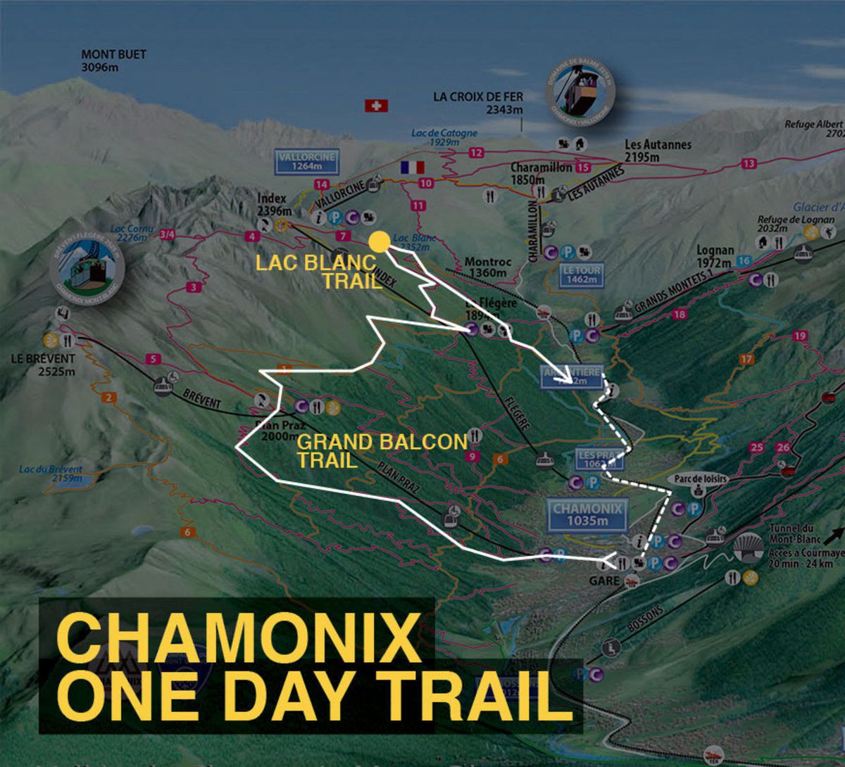
In order to create one full-day epic trail, we are going to combine 2 trails: the Grand Balcon and Lac Blanc trails, both of which allow you to see the Alps from a very unique perspective. The Grand Balcon trail is a half-day trail that offers an unobstructed view of the Mont Blanc mountain range all the way. The Lac Blanc trail, which is adjacent to the Grand Balcon, is another great walk you can do on the same day. This trail will reward you with a panoramic reflection of the mountain range on a lake. Really, the photos don't do justice to this place.
Note: I did this hike in late September after the lifts had closed, which meant I had to walk the entire route from the valley and had a much quieter experience at Lac Blanc. You do not have to wait until the lifts close, though. For most hikers, July through September is the main season for this high-altitude route, depending on snow and weather conditions. If you want to recreate my full walk-up/walk-down route in autumn, check the current trail conditions, daylight hours, and Brévent-Flégère lift dates before setting out, as the operating season changes from year to year.
- Alpenrose Chamonix (Budget)
- Hotel Richemond (Mid-Range) 👍 Top Pick
- Grand Hôtel des Alpes (High-End)
- Paragliding Tandem Flight over the Alps in Chamonix (1 hour 15 minutes)
- Chamonix, Tandem paragliding in Planpraz (1 hour)
- Mythical Aiguille du Midi - Half Day (3 hours)
One downside is that you will have to walk up and down yourself, which may add at least 5 hours to the trail. But if you know me, I very much prefer walking up than taking the cable cars anyway because you get the chance to see more wild animals.

Start your hike as early as possible; 8 AM was my starting time when I did this route. I ended up missing the last train from Argentière and had to walk back along the road in pitch darkness for about 2 hours, which is definitely not something you want to do after a long day in the mountains. Train and bus schedules change throughout the year, so check the current Mont-Blanc Express and Chamonix Mobilité timetables before you leave and work backward from the last practical connection to Chamonix.

Walk towards the tourist information, go past it, and head west up the hill to where the cable car station to PlanPraz is. From there, you should see a sign directing you to the walking trail to PlanPraz. Follow the trail up the mountain.

It's a 3-hour continuous ascent along the side of a mountain. If you are lucky enough, you will be able to spot many wild animals, such as the Chamois or a big group of mountain goats.

Our first stop is PlanPraz, where we can rest for a bit and enjoy our breakfast/lunch. From here, the trail will be a piece of cake compared to the ascent we just did.

Some of the paths we have to take along the Grand Balcon may also be covered in snow during this time of year, so be cautious.

As you walk towards La Flegere refuge, our second stop, don't forget to look back at the towering Mont Blanc and its siblings. Beautiful, isn't it?

As you make your way forward, you will have the entire mountain range on your right all the way to the second stop. Look at the photo above. This is why I love the French Alps more. The peaks around this part of the Alps are magnificent!

You should reach La Flegere refuge in about 2 hours. From here, the trail to Lac Blanc might get a little tricky, so look for the yellow directional sign and follow the direction to Lac Blanc.

Basically, what I did was walk up to the big house on top of a hill, and from there, I was able to spot a restaurant nearby with a trail behind it. I walked down the hill and up again to the restaurant, and as expected, through the restaurant, the hiking trail to Lac Blanc was accessible.

I thought the trail could not get any better than this, but I was so wrong. Lac Blanc sits at 2,352 meters above sea level inside the Aiguilles Rouges Nature Reserve. The trail consisted of many stairs zigzagging up the side of the mountain. It looked almost as if I were walking up to heaven. Keep in mind that swimming is now prohibited at Lac Blanc and the nearby Lacs des Chéserys, and dogs are not allowed inside the nature reserve.

After about an hour and a half, you should be at an intersection where, on your left, it will take you to Lac Blanc and, on your right, to Argentiere. Go left and follow the trail up the mountain until you reach the lake.
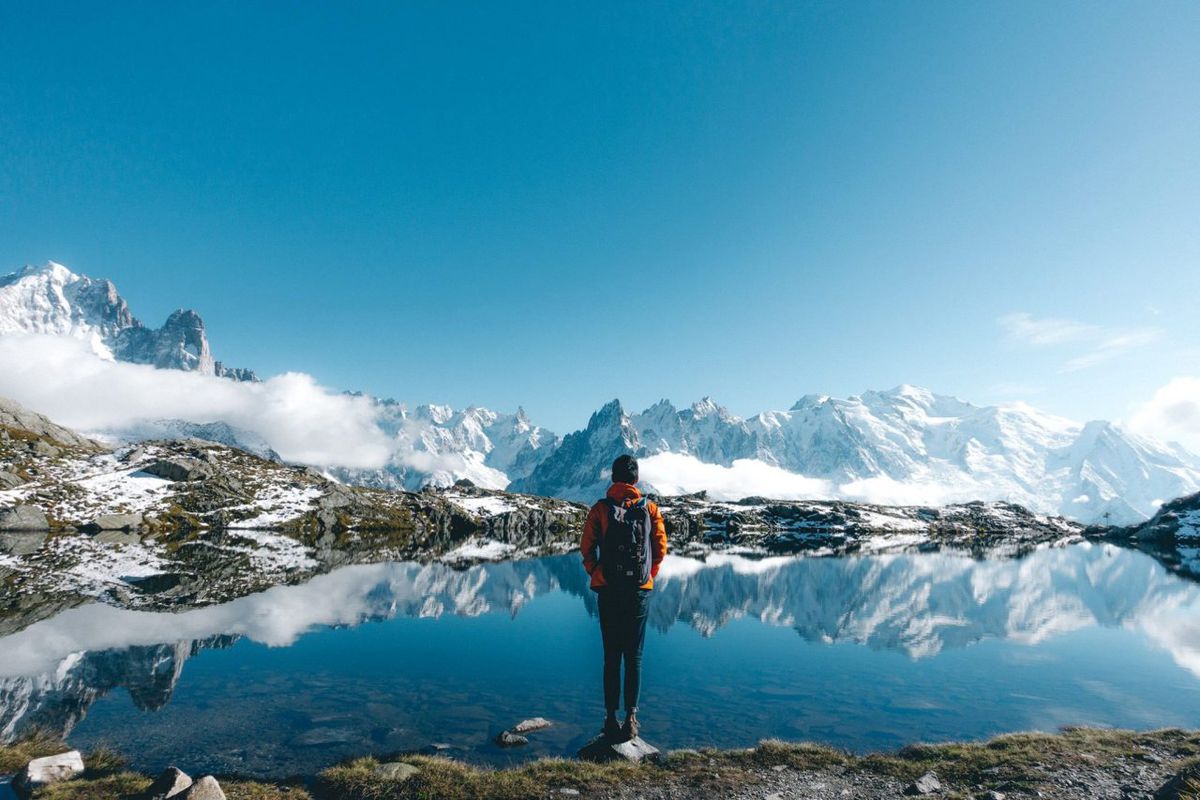
My jaw dropped to the ground as I approached the lake. Oh, it was so beautiful. When you are up there, spare some time to just sit and watch the panoramic reflection of the mountain range showing itself when the wind is calm.

If all my calculations are correct (don't take my word for it), you should have an hour up there before you have to descend. I spent a little bit too much time here, which may be the reason why I missed the last train.

From the lake, you will have to walk back down the same way until you reach the intersection again. This time, follow your way down to Argentière.

If you think all of this is adventurous, wait until you see the path down. As mentioned earlier, in order to get down from Lac Blanc, you will have to go through several sections of metal ladders where you have to hang off the cliff to go down the ladder. I still remember my legs shaking uncontrollably when I got down!

If you come down the right way, you should see Aiguillette d'Argentiere, a very iconic pair of twin spires that protrude out of Mother Earth. You cannot miss it.

From there, it should take you no more than an hour to arrive at our final destination, Argentière. From here, you can either take a bus or a train back to Chamonix, which ends this one full-day epic hike.
Bonus: Aiguille du Midi

If you have some time to spare, I would highly recommend going up the cable car to Aiguille du Midi the next day. In 2026, an adult round-trip ticket from Chamonix costs between 60.20 EUR and 83 EUR depending on the date, and a free reservation is mandatory. The cable car takes you to the summit complex at 3,842 meters, where you get incredible panoramic views across the French, Swiss, and Italian Alps. From up there, you can look back across the mountains and appreciate just how much ground you covered the day before.
Where to Stay in Chamonix?


What to Pack for the French Alps?
Since we are not ascending Mont Blanc, the required gear is not too complicated. However, the weather does get cold in the morning and at night, especially during autumn. The weather can change really fast here. One minute, you could be seeing a clear sky, and another minute, your range of sight could be reduced to zero due to fog.
- Hiking Shoes with good grip: During autumn, there is a chance that you might have to walk on a snow-covered trail, so hiking shoes are essential. Also, the way down from Lac Blanc will require you to climb down a very slippery metal ladder along the cliff side of a mountain. It's very dangerous! These Timberland Shoes are my go-to hiking boots in most situations.
- Weather-proof Clothing: It is always better to be over-prepared than the other way around. The wind is strong and it might carry heavy rain with it. Here are the jackets I recommend you get for the trip: fleece jacket and the beautiful orange Columbia outer-shell jacket.
- A Hiking Map: You can get a hiking map and current transport information from the Tourist Office. You will need to plan your return from Argentière to Chamonix carefully: the Mont-Blanc Express serves Argentière and Chamonix, and buses also run through the valley. Check the timetable for the exact day of your hike rather than relying on an old last-train time. You can also download my map from the link under The French Alps' Trails above.
- Food and water supply: It's going to be a full-day hike from 8 AM to around 6 PM, so prepare your food for at least three meals. Also, make sure you bring enough water. There were not many stops where you could fill up your water along the trail. Even if they do have stops, they are probably closed during autumn. I always carry my 2-liter hydration pack, which I recommend so you don't have to stop to stay hydrated.
- A Daypack: You will need a daypack to carry all your gear with you when you are out and about. During this trip, I use the classic Herschel Supply's Little America Backpack to carry everything with me. It is lightweight with good capacity and stylish as hell.
How to get to Chamonix?
For most international travelers, the easiest airport for Chamonix is Geneva Airport in Switzerland, which is roughly an hour away by road. Lyon is another option, but it is considerably farther from Chamonix. I would recommend you browse through Skyscanner or Expedia to compare flights and find the option that best fits your itinerary.
Chamonix is the main base for this hike and is connected by road, bus, and rail with the surrounding region. I came by SNCF train from Lyon, so that part of the guide reflects the route I personally took. Today, the Mont-Blanc Express links Chamonix with Saint-Gervais-les-Bains-Le Fayet on the French side and continues toward Martigny in Switzerland, while Geneva is also well connected to Chamonix by road transfers.
If you are coming from Geneva Airport, direct transfer services such as Alpybus connect the airport with Chamonix. You can also compare long-distance bus connections with Flixbus. If you prefer rail, Chamonix is connected to the regional train network via the Mont-Blanc Express, although the train journey from Geneva requires connections and is generally slower than a direct road transfer.
For the cheapest option with a little bit of luck, you can try the carpool service called Blablacar.com, which allows you to carpool with people who are going the same way for a small fee. I have never done it myself, but I have heard great stories from the locals.
Disclaimer: This post may contain affiliate links. See our disclosure policy.
First Published:
Last updated:


22 Comments
Amazing!
Thank you for the comment! :)
Pete Rojwongsuriya Your wellcome. Is it possible to do it alone, iI mean, not necessarily paying a guide or with a group? Thank you.
João Leite Yes. :) I did them all alone in one day. As long as you prepare enough food and study the trail carefully, it shouldn't be a problem :)
This is just what I was looking for! Do you know if there's a cable car station(?) at the end/near of Lac Blanc trail? I am thinking I want to take the cable down instead of walking down.
Thank you Allison! The hike is totally worth it :) I believe in order to come back down to Chamonix via cable car, you will have to make your way back to La Flegere and go down from there. Be aware that the cable car station maybe close earlier than when you finish the hike so calculate your time carefully. I'm not sure the operating hours of the cable cars (because it depends on the season) but it switzerland side of the Alps, it closed at 4:30 PM and I had to walk (run) 3 hours down in order to make it before it got too dark. I hope this helps!
PlanPraz*
Thank you, Maxwell! The names are fixed :)
How did you take such great photos while by yourself? So beautiful! Also I'm very scared to do those ladders down, are they reasonably safe?
Thank you, Stephanie! :)
Haha, I get that question a lot. I simply carry a tripod around and when there is no one around, I just set the camera up on a tripod and use a timer and run :D They are pretty safe if you have solid shoes and it is not pouring outside. :) Just go slowly and you should be fine :)